IMAGES TAKEN NEAR TO
Chalford, WESTBURY, BA13 3RE
Introduction
This page details the photographs taken nearby to Chalford, BA13 3RE by members of the Geograph project.
The Geograph project started in 2005 with the aim of publishing, organising and preserving representative images for every square kilometre of Great Britain, Ireland and the Isle of Man.

There are currently over 7.5m images from over14,400 individuals and you can help contribute to the project by visiting https://www.geograph.org.uk
Image Map
Images are licensed for reuse under creativecommons.org/licenses/by-sa/2.0
Notes
- Clicking on the map will re-center to the selected point.
- The higher the marker number, the further away the image location is from the centre of the postcode.
Image Listing (10 Images Found)
Images are licensed for reuse under creativecommons.org/licenses/by-sa/2.0
Image
Details
Distance

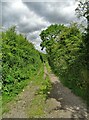
2

2010 : Chalford near Westbury, Wilts
Seen from a footpath near the bottom of Upton Cow Down.
Image: © Maurice Pullin
Taken: 4 Apr 2010
0.10 miles
4
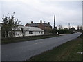
Madbrook Farm, Westbury
Looking north along the A350 towards Madbrook Farm on the outskirts of Westbury.
Image: © Phil Williams
Taken: 27 Nov 2005
0.17 miles

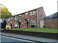
7
![Westbury houses [36]](https://s1.geograph.org.uk/geophotos/06/82/74/6827461_e2cb694c_120x120.jpg)
Westbury houses [36]
Numbers 21 and 23 Chalford are early 19th century with later rear extensions. Built in brick, now roughcast with a triple Roman tile roof. A stream flows underneath the houses. Listed, grade II, with details at: https://historicengland.org.uk/listing/the-list/list-entry/1285072
Westbury is a former market town in the far west of Wiltshire under the north western edge of Salisbury Plain, 4 miles south of Trowbridge and 4 miles north of Warminster. Westbury was a centre of the cloth industry from the later 15th century until the 19th century. Malting was another important industry. There are now a number of large industrial and trading estates around the town with many residents working there. The town is an important junction point on the railway network with the Reading to Taunton line intersecting the line from Bristol to Southampton.
Image: © Michael Dibb
Taken: 29 Apr 2021
0.19 miles
8
![Westbury buildings [19]](https://s3.geograph.org.uk/geophotos/06/82/74/6827459_a87a25dc_120x120.jpg)
Westbury buildings [19]
The Bell Inn, number 19 Chalford, was built circa 1720. Constructed of painted brick under a pantiled roof. Much altered in the late 19th or early 20th century. Listed, grade II, with details at: https://historicengland.org.uk/listing/the-list/list-entry/1364402
Westbury is a former market town in the far west of Wiltshire under the north western edge of Salisbury Plain, 4 miles south of Trowbridge and 4 miles north of Warminster. Westbury was a centre of the cloth industry from the later 15th century until the 19th century. Malting was another important industry. There are now a number of large industrial and trading estates around the town with many residents working there. The town is an important junction point on the railway network with the Reading to Taunton line intersecting the line from Bristol to Southampton.
Image: © Michael Dibb
Taken: 29 Apr 2021
0.21 miles
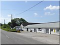
9
Terrace of houses on the A350, Westbury Leigh
Image: © David Howard
Taken: 5 May 2018
0.22 miles
10
![Westbury ways [9]](https://s0.geograph.org.uk/geophotos/06/82/74/6827464_8dfe1e45_120x120.jpg)
Westbury ways [9]
Laverton Road runs from Warminster Road to Leigh Road. The wall topped with razor wire on the right of the road is the boundary wall to the Leighton House estate.
The estate is occupied by the Army Officer Selection Board, an assessment centre used by the British Army as part of the officer selection process for the regular army and Army Reserve. The 40 acre estate comprises the grade II* listed, 19th century Leighton House, a trout lake and an assault course where potential officers are put through their paces. The estate is due to be sold for housing in 2024.
The Leighton House estate is occupied by the Army Officer Selection Board, an assessment centre used by the British Army as part of the officer selection process for the regular army and Army Reserve. The 40 acre estate comprises the grade II* listed, 19th century Leighton House, a trout lake and an assault course where potential officers are put through their paces. The estate is due to be sold for housing in 2024.
Westbury is a former market town in the far west of Wiltshire under the north western edge of Salisbury Plain, 4 miles south of Trowbridge and 4 miles north of Warminster. Westbury was a centre of the cloth industry from the later 15th century until the 19th century. Malting was another important industry. There are now a number of large industrial and trading estates around the town with many residents working there. The town is an important junction point on the railway network with the Reading to Taunton line intersecting the line from Bristol to Southampton.
Image: © Michael Dibb
Taken: 29 Apr 2021
0.25 miles