IMAGES TAKEN NEAR TO
Warminster Road, WESTBURY, BA13 3PE
Introduction
This page details the photographs taken nearby to Warminster Road, BA13 3PE by members of the Geograph project.
The Geograph project started in 2005 with the aim of publishing, organising and preserving representative images for every square kilometre of Great Britain, Ireland and the Isle of Man.

There are currently over 7.5m images from over14,400 individuals and you can help contribute to the project by visiting https://www.geograph.org.uk
Image Map
Images are licensed for reuse under creativecommons.org/licenses/by-sa/2.0
Notes
- Clicking on the map will re-center to the selected point.
- The higher the marker number, the further away the image location is from the centre of the postcode.
Image Listing (373 Images Found)
Images are licensed for reuse under creativecommons.org/licenses/by-sa/2.0
Image
Details
Distance
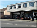
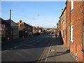
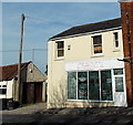
1
![Westbury buildings [13]](https://s0.geograph.org.uk/geophotos/06/82/59/6825960_30f8305d_120x120.jpg)
Westbury buildings [13]
Number 24 Warminster Road is an early 19th century building spoilt by the hideous shop front. Constructed in Bath stone ashlar with a slate roof. There are some fine cast iron railings to the two bays on the right. Listed, grade II, with details at: https://historicengland.org.uk/listing/the-list/list-entry/1285056
Westbury is a former market town in the far west of Wiltshire under the north western edge of Salisbury Plain, 4 miles south of Trowbridge and 4 miles north of Warminster. Westbury was a centre of the cloth industry from the later 15th century until the 19th century. Malting was another important industry. There are now a number of large industrial and trading estates around the town with many residents working there. The town is an important junction point on the railway network with the Reading to Taunton line intersecting the line from Bristol to Southampton.
Image: © Michael Dibb
Taken: 29 Apr 2021
0.01 miles
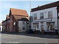
2
Imperial Charity, Westbury
Imperial Charity was founded in 1990 by David McCance. It is administered by trustees and committee members who have a deep understanding of Special Needs. They are committed to helping children and adults improve their quality of life. The charity's chief source of income is from the sale of donated items at their charity shops. This one is at 27 Warminster Road, Westbury.
The shop on the left is named The Flower Shop but appeared vacant at the March 2014 date of this view.
Image: © Jaggery
Taken: 8 Mar 2014
0.01 miles
3
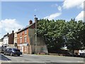
Buttressed house at junction of B3098 and A350, Westbury
Image: © David Smith
Taken: 1 Jun 2017
0.02 miles
4
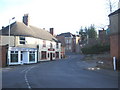
Warminster Road
At the end of Warminster road looking northeast to its junction with Edward street (left) and Bratton road (ahead). The corner of Oddfellows Hall can be seen in front of the Laverton Hall, with Bereswell Cottage at left just above the bushes.
Image: © Phil Williams
Taken: 17 Dec 2005
0.02 miles
5
Warminster Road, Westbury
Looking northeast along Warminster Road to its junction with Edward Street.
Image: © Phil Williams
Taken: 17 Dec 2005
0.02 miles
6
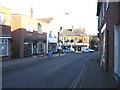
Haynes Road, Westbury
Looking northwest down the A350, Haynes Road from Warminster Road. The A350 is major route for ferry traffic from Poole to the M4 motorway. The brick building at the end of the road in the distance is Eastleigh surgery. Westbury High street is just off to the right where the two vehicles are passing.
Image: © Phil Williams
Taken: 17 Dec 2005
0.02 miles
7
Sweetie's Cakery in Westbury
Wedding and celebration cake shop at 15 Warminster Road, opposite Haynes Road.
Image: © Jaggery
Taken: 8 Mar 2014
0.02 miles
8
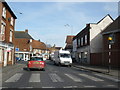
Pedestrian crossing, Warminster Road, Westbury
Image: © Roger Cornfoot
Taken: 16 Feb 2009
0.03 miles
9
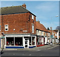
It's New to You, Westbury
Second-hand furniture shop on the corner of Warminster Road and Haynes Road.
Image: © Jaggery
Taken: 8 Mar 2014
0.03 miles
10
Former Belle of the Ball Bridals shop to let in Westbury
Viewed across Haynes Road in early March 2014.
Image: © Jaggery
Taken: 8 Mar 2014
0.03 miles