IMAGES TAKEN NEAR TO
Station Road, WESTBURY, BA13 3JS
Introduction
This page details the photographs taken nearby to Station Road, BA13 3JS by members of the Geograph project.
The Geograph project started in 2005 with the aim of publishing, organising and preserving representative images for every square kilometre of Great Britain, Ireland and the Isle of Man.

There are currently over 7.5m images from over14,400 individuals and you can help contribute to the project by visiting https://www.geograph.org.uk
Image Map
Images are licensed for reuse under creativecommons.org/licenses/by-sa/2.0
Notes
- Clicking on the map will re-center to the selected point.
- The higher the marker number, the further away the image location is from the centre of the postcode.
Image Listing (36 Images Found)
Images are licensed for reuse under creativecommons.org/licenses/by-sa/2.0
Image
Details
Distance
3
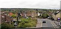
B3097 at Westbury
Station Road seen from a passing train on the line to Pewsey that bypasses the station.
Image: © Derek Harper
Taken: 30 Sep 2015
0.03 miles
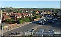
5
Westbury : Rooftops and Houses
Rooftops and houses in Westbury as seen from a passing train not heading into the nearby station.
Image: © Lewis Clarke
Taken: 1 Sep 2011
0.06 miles
6
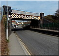
Station Road railway bridge, Westbury
The B3097 Station Road passes under a railway bridge, headroom 14 feet.
Image: © Jaggery
Taken: 8 Mar 2014
0.07 miles
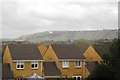
7

Westbury : Aerial Scenery
Looking down towards Westbury from above the clouds.
Image: © Lewis Clarke
Taken: 8 Jun 2022
0.09 miles
8
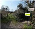
Private land at the edge of a Westbury lake
I was wondering whether I could circumambulate the edge of this http://www.geograph.org.uk/photo/4500750 lake. Then I saw these signs...
Image: © Jaggery
Taken: 8 Mar 2014
0.09 miles
9
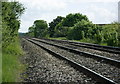
2008 : The Westbury bypass line (2)
Not a place to linger. The line is mostly used by high speed trains avoiding Westbury Station. It can also be used by freight trains carrying stone from the Mendips.
This was taken from a public footpath crossing the track.
Image: © Maurice Pullin
Taken: 19 May 2008
0.09 miles
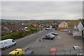
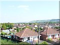
10
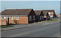
Rosefield Way bungalows, Westbury
Viewed from the corner of Station Road looking towards the Summer Road junction.
Strictly, a bungalow is a lightly-built house, with a veranda and one storey.
In current UK usage it is a convenient word for any one-storey dwelling.
Image: © Jaggery
Taken: 8 Mar 2014
0.10 miles