IMAGES TAKEN NEAR TO
Bratton Road, WESTBURY, BA13 3EP
Introduction
This page details the photographs taken nearby to Bratton Road, BA13 3EP by members of the Geograph project.
The Geograph project started in 2005 with the aim of publishing, organising and preserving representative images for every square kilometre of Great Britain, Ireland and the Isle of Man.

There are currently over 7.5m images from over14,400 individuals and you can help contribute to the project by visiting https://www.geograph.org.uk
Image Map (Loading...)


Getting Data...Please wait
Leaflet Map data © OpenStreetMap
Images are licensed for reuse under creativecommons.org/licenses/by-sa/2.0
Notes
- Clicking on the map will re-center to the selected point.
- The higher the marker number, the further away the image location is from the centre of the postcode.
Image Listing (483 Images Found)
Images are licensed for reuse under creativecommons.org/licenses/by-sa/2.0
Image
Details
Distance
2
![Westbury features [9]](https://s2.geograph.org.uk/geophotos/06/82/86/6828654_3767a1ec_120x120.jpg)
Westbury features [9]
A view of Prospect Square looking down towards Bratton Road. Seen from in front of the almshouses Image
Prospect Square, a development of thirty-nine houses, was built by mill owner Abraham Laverton. Thirty-two were for his mill workers and seven were almshouses. The square is built on a sloping site around three sides of a large open space. The groups of stepped houses are in a revived vernacular style. Each group is of a different design reflected across the central axis.
Westbury is a former market town in the far west of Wiltshire under the north western edge of Salisbury Plain, 4 miles south of Trowbridge and 4 miles north of Warminster. Westbury was a centre of the cloth industry from the later 15th century until the 19th century. Malting was another important industry. There are now a number of large industrial and trading estates around the town with many residents working there. The town is an important junction point on the railway network with the Reading to Taunton line intersecting the line from Bristol to Southampton.
Image: © Michael Dibb
Taken: 29 Apr 2021
0.04 miles
3
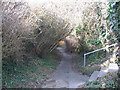
Chantry footpath
A view looking northwest down to Chantry Lane along the footpath from Bratton Road.
Image: © Phil Williams
Taken: 25 Feb 2006
0.05 miles
4
![Westbury houses [38]](https://s2.geograph.org.uk/geophotos/06/82/85/6828582_6fc5163f_120x120.jpg)
Westbury houses [38]
Numbers 38 and 39 Prospect Square were built in 1869 of coursed rubble stone with brick chimneys, quoins and bands under a tiled roof. The entrances are in the flanking tile hung extensions. Numbers 1 and 2 Prospect Square at Image are the same design, reflected. Listed, grade II, with details at: https://historicengland.org.uk/listing/the-list/list-entry/1364422
Prospect Square, a development of thirty-nine houses, was built by mill owner Abraham Laverton. Thirty-two were for his mill workers and seven were almshouses. The square is built on a sloping site around three sides of a large open space. The groups of stepped houses are in a revived vernacular style. Each group is of a different design reflected across the central axis.
Westbury is a former market town in the far west of Wiltshire under the north western edge of Salisbury Plain, 4 miles south of Trowbridge and 4 miles north of Warminster. Westbury was a centre of the cloth industry from the later 15th century until the 19th century. Malting was another important industry. There are now a number of large industrial and trading estates around the town with many residents working there. The town is an important junction point on the railway network with the Reading to Taunton line intersecting the line from Bristol to Southampton.
Image: © Michael Dibb
Taken: 29 Apr 2021
0.05 miles
5
![Westbury houses [44]](https://s1.geograph.org.uk/geophotos/06/83/03/6830389_88957d9d_120x120.jpg)
Westbury houses [44]
Number 50 Bratton Road is a mid 19th century detached house with a later addition on the left. Constructed in red brick with a slate roof. The 9 chimney stacks are octagonal and there is a nice lattice porch. Listed, grade II, with https://historicengland.org.uk/listing/the-list/list-entry/1364423
Westbury is a former market town in the far west of Wiltshire under the north western edge of Salisbury Plain, 4 miles south of Trowbridge and 4 miles north of Warminster. Westbury was a centre of the cloth industry from the later 15th century until the 19th century. Malting was another important industry. There are now a number of large industrial and trading estates around the town with many residents working there. The town is an important junction point on the railway network with the Reading to Taunton line intersecting the line from Bristol to Southampton.
Image: © Michael Dibb
Taken: 29 Apr 2021
0.05 miles
6
![Westbury houses [39]](https://s3.geograph.org.uk/geophotos/06/82/86/6828615_c574161d_120x120.jpg)
Westbury houses [39]
Numbers 34 to 37 Prospect Square were built in 1869 of coursed rubble stone with brick chimneys, quoins and lacing courses under a tiled roof. The repointing of number 36 is very poor. Numbers 3 to 6 Prospect Square at Image are the same design, reflected. Listed, grade II, with details at: https://historicengland.org.uk/listing/the-list/list-entry/1180374
Prospect Square, a development of thirty-nine houses, was built by mill owner Abraham Laverton. Thirty-two were for his mill workers and seven were almshouses. The square is built on a sloping site around three sides of a large open space. The groups of stepped houses are in a revived vernacular style. Each group is of a different design reflected across the central axis.
Westbury is a former market town in the far west of Wiltshire under the north western edge of Salisbury Plain, 4 miles south of Trowbridge and 4 miles north of Warminster. Westbury was a centre of the cloth industry from the later 15th century until the 19th century. Malting was another important industry. There are now a number of large industrial and trading estates around the town with many residents working there. The town is an important junction point on the railway network with the Reading to Taunton line intersecting the line from Bristol to Southampton.
Image: © Michael Dibb
Taken: 29 Apr 2021
0.05 miles
7
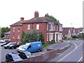
Westfield House, Bratton Road, Westbury
Westfield House, surrounded by a small public carpark, seen from upstairs at the Laverton Institute.
Image: © Steve Roberts
Taken: 13 May 2016
0.05 miles
8
![Westbury ways [10]](https://s2.geograph.org.uk/geophotos/06/83/03/6830390_6f9988c0_120x120.jpg)
Westbury ways [10]
From Bratton Road this public footpath leads to Chantry Lane.
Westbury is a former market town in the far west of Wiltshire under the north western edge of Salisbury Plain, 4 miles south of Trowbridge and 4 miles north of Warminster. Westbury was a centre of the cloth industry from the later 15th century until the 19th century. Malting was another important industry. There are now a number of large industrial and trading estates around the town with many residents working there. The town is an important junction point on the railway network with the Reading to Taunton line intersecting the line from Bristol to Southampton.
Image: © Michael Dibb
Taken: 29 Apr 2021
0.06 miles
9
![Westbury houses [74]](https://s3.geograph.org.uk/geophotos/06/83/89/6838999_ede299c8_120x120.jpg)
Westbury houses [74]
Number 12 Church Street was built in the early 18th century refaced in the late 18th century. Constructed of brick on a stone plinth with stone quoins under a double Roman tile roof. Originally there was an attic floor. There is a modern buttress on the left. Some original internal features remain. Listed, grade II, with details at: https://historicengland.org.uk/listing/the-list/list-entry/1036280
Westbury is a former market town in the far west of Wiltshire under the north western edge of Salisbury Plain, 4 miles south of Trowbridge and 4 miles north of Warminster. Westbury was a centre of the cloth industry from the later 15th century until the 19th century. Malting was another important industry. There are now a number of large industrial and trading estates around the town with many residents working there. The town is an important junction point on the railway network with the Reading to Taunton line intersecting the line from Bristol to Southampton.
Image: © Michael Dibb
Taken: 29 Apr 2021
0.06 miles
10
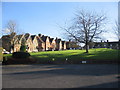
Prospect Square, Westbury
Looking southeast to Prospect Square which lies to the south of Bratton Road. This was laid out by Abraham Laverton, and comprises 39 brick and stone built houses, of which 7 are almshouses, around three sides of an open space, formerly used as allotment gardens.
Image: © Phil Williams
Taken: 17 Dec 2005
0.07 miles