IMAGES TAKEN NEAR TO
Cannon Green, WESTBURY, BA13 3DW
Introduction
This page details the photographs taken nearby to Cannon Green, BA13 3DW by members of the Geograph project.
The Geograph project started in 2005 with the aim of publishing, organising and preserving representative images for every square kilometre of Great Britain, Ireland and the Isle of Man.

There are currently over 7.5m images from over14,400 individuals and you can help contribute to the project by visiting https://www.geograph.org.uk
Image Map
Images are licensed for reuse under creativecommons.org/licenses/by-sa/2.0
Notes
- Clicking on the map will re-center to the selected point.
- The higher the marker number, the further away the image location is from the centre of the postcode.
Image Listing (490 Images Found)
Images are licensed for reuse under creativecommons.org/licenses/by-sa/2.0
Image
Details
Distance
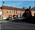
1
![Westbury houses [68]](https://s0.geograph.org.uk/geophotos/06/83/71/6837104_b5c3e1fa_120x120.jpg)
Westbury houses [68]
This terrace of three houses, numbers 1 to 3 Cannon Green are set back into Churchyard. Built in the 18th century in brick on stone plinths with old tile roofs. Listed, grade II, with details at: https://historicengland.org.uk/listing/the-list/list-entry/1036275
Westbury is a former market town in the far west of Wiltshire under the north western edge of Salisbury Plain, 4 miles south of Trowbridge and 4 miles north of Warminster. Westbury was a centre of the cloth industry from the later 15th century until the 19th century. Malting was another important industry. There are now a number of large industrial and trading estates around the town with many residents working there. The town is an important junction point on the railway network with the Reading to Taunton line intersecting the line from Bristol to Southampton.
Image: © Michael Dibb
Taken: 29 Apr 2021
0.00 miles
2
![Westbury features [10]](https://s0.geograph.org.uk/geophotos/06/83/12/6831284_b6972c8d_120x120.jpg)
Westbury features [10]
At the southern end of Market Place these gates lead into the churchyard of All Saints parish church. The stone gate piers are mid 19th century and the cast iron gates have some fine scrollwork. Listed, grade II, with details at: https://historicengland.org.uk/listing/the-list/list-entry/1364399
Westbury is a former market town in the far west of Wiltshire under the north western edge of Salisbury Plain, 4 miles south of Trowbridge and 4 miles north of Warminster. Westbury was a centre of the cloth industry from the later 15th century until the 19th century. Malting was another important industry. There are now a number of large industrial and trading estates around the town with many residents working there. The town is an important junction point on the railway network with the Reading to Taunton line intersecting the line from Bristol to Southampton.
Image: © Michael Dibb
Taken: 29 Apr 2021
0.00 miles
3
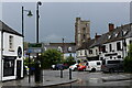
Market Place, Westbury
Centre of the Wiltshire town of Westbury, dominated by the tower of All Saints Church.
Image: © Chris Heaton
Taken: 18 May 2021
0.01 miles
4
Lopes Arms
Westbury's old pub on Market Square is named after a local lord, Sir Manasseh Massey Lopes. He came from Maristow in Devon (a road is named after that) and acquired the rights to the town in the nineteenth century from the Earl of Abingdon.
Image: © Neil Owen
Taken: 26 Feb 2014
0.01 miles
5
The Lopes Arms, Westbury
Town centre pub in Market Place.
Image: © Jaggery
Taken: 8 Mar 2014
0.01 miles
6
![Westbury buildings [26]](https://s0.geograph.org.uk/geophotos/06/83/12/6831292_845fa393_120x120.jpg)
Westbury buildings [26]
The Lopes Arms Hotel, Market Place, closed in 2015. Reputed to be on the site of a 14th century inn, the present building is mostly 18th century with later additions and alterations. Constructed of red brick under an old tiled roof. Previously known as the Saint George & Dragon and as the Lord Abingdon Arms, it was renamed the Lopes Arms after a fire in 1809. It became The Westbury in 1989 and the name was changed back to the Lopes Arms in 2007. Listed, grade II, with details at: https://historicengland.org.uk/listing/the-list/list-entry/1036309
Westbury is a former market town in the far west of Wiltshire under the north western edge of Salisbury Plain, 4 miles south of Trowbridge and 4 miles north of Warminster. Westbury was a centre of the cloth industry from the later 15th century until the 19th century. Malting was another important industry. There are now a number of large industrial and trading estates around the town with many residents working there. The town is an important junction point on the railway network with the Reading to Taunton line intersecting the line from Bristol to Southampton.
Image: © Michael Dibb
Taken: 29 Apr 2021
0.01 miles
7
![Westbury buildings [27]](https://s1.geograph.org.uk/geophotos/06/83/12/6831293_1c450801_120x120.jpg)
Westbury buildings [27]
The entrance to the Lopes Arms Hotel.
The Lopes Arms Hotel, Market Place, closed in 2015. Reputed to be on the site of a 14th century inn, the present building is mostly 18th century with later additions and alterations. Constructed of red brick under an old tiled roof. Previously known as the Saint George & Dragon and as the Lord Abingdon Arms, it was renamed the Lopes Arms after a fire in 1809. It became The Westbury in 1989 and the name was changed back to the Lopes Arms in 2007. Listed, grade II, with details at: https://historicengland.org.uk/listing/the-list/list-entry/1036309
Westbury is a former market town in the far west of Wiltshire under the north western edge of Salisbury Plain, 4 miles south of Trowbridge and 4 miles north of Warminster. Westbury was a centre of the cloth industry from the later 15th century until the 19th century. Malting was another important industry. There are now a number of large industrial and trading estates around the town with many residents working there. The town is an important junction point on the railway network with the Reading to Taunton line intersecting the line from Bristol to Southampton.
Image: © Michael Dibb
Taken: 29 Apr 2021
0.01 miles
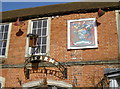
8
![Westbury buildings [28]](https://s2.geograph.org.uk/geophotos/06/83/12/6831294_30b93929_120x120.jpg)
Westbury buildings [28]
A plaque on the Lopes Arms Hotel.
The Lopes Arms Hotel, Market Place, closed in 2015. Reputed to be on the site of a 14th century inn, the present building is mostly 18th century with later additions and alterations. Constructed of red brick under an old tiled roof. Previously known as the Saint George & Dragon and as the Lord Abingdon Arms, it was renamed the Lopes Arms after a fire in 1809. It became The Westbury in 1989 and the name was changed back to the Lopes Arms in 2007. Listed, grade II, with details at: https://historicengland.org.uk/listing/the-list/list-entry/1036309
Westbury is a former market town in the far west of Wiltshire under the north western edge of Salisbury Plain, 4 miles south of Trowbridge and 4 miles north of Warminster. Westbury was a centre of the cloth industry from the later 15th century until the 19th century. Malting was another important industry. There are now a number of large industrial and trading estates around the town with many residents working there. The town is an important junction point on the railway network with the Reading to Taunton line intersecting the line from Bristol to Southampton.
Image: © Michael Dibb
Taken: 29 Apr 2021
0.01 miles
9
![Westbury buildings [29]](https://s3.geograph.org.uk/geophotos/06/83/12/6831295_a243b43c_120x120.jpg)
Westbury buildings [29]
A sign on the Lopes Arms Hotel.
The Lopes Arms Hotel, Market Place, closed in 2015. Reputed to be on the site of a 14th century inn, the present building is mostly 18th century with later additions and alterations. Constructed of red brick under an old tiled roof. Previously known as the Saint George & Dragon and as the Lord Abingdon Arms, it was renamed the Lopes Arms after a fire in 1809. It became The Westbury in 1989 and the name was changed back to the Lopes Arms in 2007. Listed, grade II, with details at: https://historicengland.org.uk/listing/the-list/list-entry/1036309
Westbury is a former market town in the far west of Wiltshire under the north western edge of Salisbury Plain, 4 miles south of Trowbridge and 4 miles north of Warminster. Westbury was a centre of the cloth industry from the later 15th century until the 19th century. Malting was another important industry. There are now a number of large industrial and trading estates around the town with many residents working there. The town is an important junction point on the railway network with the Reading to Taunton line intersecting the line from Bristol to Southampton.
Image: © Michael Dibb
Taken: 29 Apr 2021
0.01 miles
10
![Westbury houses [83]](https://s2.geograph.org.uk/geophotos/06/83/99/6839958_5c214fab_120x120.jpg)
Westbury houses [83]
Verger's Cottage in Churchyard is of three stages from the early 19th century and earlier. Built in brick under a pantile roof. The part on the right was formerly a barn and the gable end and rear are weatherboarded. Listed, grade II, with details at: https://historicengland.org.uk/listing/the-list/list-entry/1036287
Westbury is a former market town in the far west of Wiltshire under the north western edge of Salisbury Plain, 4 miles south of Trowbridge and 4 miles north of Warminster. Westbury was a centre of the cloth industry from the later 15th century until the 19th century. Malting was another important industry. There are now a number of large industrial and trading estates around the town with many residents working there. The town is an important junction point on the railway network with the Reading to Taunton line intersecting the line from Bristol to Southampton.
Image: © Michael Dibb
Taken: 29 Apr 2021
0.01 miles