Westbury buildings [29]
Introduction
The photograph on this page of Westbury buildings [29] by Michael Dibb as part of the Geograph project.
The Geograph project started in 2005 with the aim of publishing, organising and preserving representative images for every square kilometre of Great Britain, Ireland and the Isle of Man.

There are currently over 7.5m images from over 14,400 individuals and you can help contribute to the project by visiting https://www.geograph.org.uk
Westbury buildings [29]
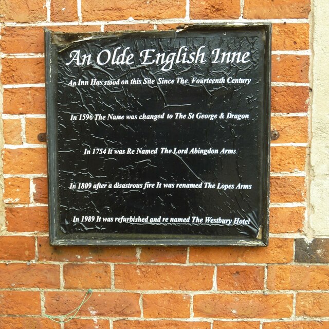
Image: © Michael Dibb Taken: 29 Apr 2021
A sign on the Lopes Arms Hotel. The Lopes Arms Hotel, Market Place, closed in 2015. Reputed to be on the site of a 14th century inn, the present building is mostly 18th century with later additions and alterations. Constructed of red brick under an old tiled roof. Previously known as the Saint George & Dragon and as the Lord Abingdon Arms, it was renamed the Lopes Arms after a fire in 1809. It became The Westbury in 1989 and the name was changed back to the Lopes Arms in 2007. Listed, grade II, with details at: https://historicengland.org.uk/listing/the-list/list-entry/1036309 Westbury is a former market town in the far west of Wiltshire under the north western edge of Salisbury Plain, 4 miles south of Trowbridge and 4 miles north of Warminster. Westbury was a centre of the cloth industry from the later 15th century until the 19th century. Malting was another important industry. There are now a number of large industrial and trading estates around the town with many residents working there. The town is an important junction point on the railway network with the Reading to Taunton line intersecting the line from Bristol to Southampton.
Images are licensed for reuse under creativecommons.org/licenses/by-sa/2.0
Image Location
Latitude
51.262337
Longitude
-2.181963