IMAGES TAKEN NEAR TO
Bitham Lane, WESTBURY, BA13 3BU
Introduction
This page details the photographs taken nearby to Bitham Lane, BA13 3BU by members of the Geograph project.
The Geograph project started in 2005 with the aim of publishing, organising and preserving representative images for every square kilometre of Great Britain, Ireland and the Isle of Man.

There are currently over 7.5m images from over14,400 individuals and you can help contribute to the project by visiting https://www.geograph.org.uk
Image Map
Images are licensed for reuse under creativecommons.org/licenses/by-sa/2.0
Notes
- Clicking on the map will re-center to the selected point.
- The higher the marker number, the further away the image location is from the centre of the postcode.
Image Listing (498 Images Found)
Images are licensed for reuse under creativecommons.org/licenses/by-sa/2.0
Image
Details
Distance
1
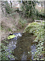
Bitham Brook
The area around this part of Westbury has provided lots of spring water, enough to allow mills to be built close by.
Image: © Neil Owen
Taken: 26 Feb 2014
0.02 miles
2
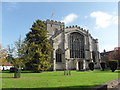
All Saints Church
The unusual west front
Image: © Kevin Farmer
Taken: 18 Oct 2009
0.03 miles
4
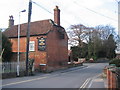
![Westbury houses [84]](https://s0.geograph.org.uk/geophotos/06/83/99/6839972_84413a6f_120x120.jpg)
Westbury houses [84]
Church View, in Churchyard is 17th or early 18th century. Built of stuccoed brick with an old tile roof. Listed, grade II, with details at: https://historicengland.org.uk/listing/the-list/list-entry/1036288
Westbury is a former market town in the far west of Wiltshire under the north western edge of Salisbury Plain, 4 miles south of Trowbridge and 4 miles north of Warminster. Westbury was a centre of the cloth industry from the later 15th century until the 19th century. Malting was another important industry. There are now a number of large industrial and trading estates around the town with many residents working there. The town is an important junction point on the railway network with the Reading to Taunton line intersecting the line from Bristol to Southampton.
Image: © Michael Dibb
Taken: 29 Apr 2021
0.03 miles
5
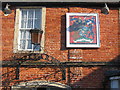
The Lopes Arms
Detail of the plaque on the wall of the Westbury Hotel, recording its previous identity as the Lopes Arms. This coat-of-arms relates to Sir Manasseh Massey Lopes, a former parliamentary representative for Westbury.
Image: © Phil Williams
Taken: 28 Jan 2006
0.04 miles
6
The Horse and Groom
A view looking northwest across Alfred Street to the entrance to Bitham lane footpath and the Horse and Groom public house beyond.
Image: © Phil Williams
Taken: 25 Feb 2006
0.04 miles
7
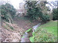
Bitham Brook
Looking northwest along Bitham Brook with the tower of All Saints church in the background. The green area is the end of the lawn at the rear of the Horse and Groom public house.
Image: © Phil Williams
Taken: 24 Dec 2005
0.04 miles
8
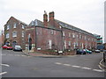
Bitham Mill
After lying derelict for many years, Bitham Mill has now been converted into residential apartments. A view looking southeast across Alfred Street.
Image: © Phil Williams
Taken: 24 Dec 2005
0.04 miles
9
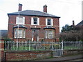
Royston House
A view looking northeast across Alfred Street to Royston House.
Image: © Phil Williams
Taken: 24 Dec 2005
0.04 miles
10
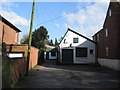
Industrial Unit on Alfred Street
A view looking east to an industrial unit off Alfred Street.
Image: © Phil Williams
Taken: 25 Feb 2006
0.04 miles