IMAGES TAKEN NEAR TO
Fore Street, WESTBURY, BA13 3AU
Introduction
This page details the photographs taken nearby to Fore Street, BA13 3AU by members of the Geograph project.
The Geograph project started in 2005 with the aim of publishing, organising and preserving representative images for every square kilometre of Great Britain, Ireland and the Isle of Man.

There are currently over 7.5m images from over14,400 individuals and you can help contribute to the project by visiting https://www.geograph.org.uk
Image Map
Images are licensed for reuse under creativecommons.org/licenses/by-sa/2.0
Notes
- Clicking on the map will re-center to the selected point.
- The higher the marker number, the further away the image location is from the centre of the postcode.
Image Listing (403 Images Found)
Images are licensed for reuse under creativecommons.org/licenses/by-sa/2.0
Image
Details
Distance
1
![Westbury houses [55]](https://s1.geograph.org.uk/geophotos/06/83/35/6833597_30b67f66_120x120.jpg)
Westbury houses [55]
Numbers 9, 11, 15 and 15A Fore Street are 4 cottages in a terrace. Built in the late 18th or early 19th century in redbrick with a pantile roof. The shop front to number 9 is a later insertion. Much of the fenestration has been altered. Listed, grade II, with details at: https://historicengland.org.uk/listing/the-list/list-entry/1181116
Fore Street suffers from being part of the busy A350 which runs through the town with a constant stream of heavy goods vehicles.
Westbury is a former market town in the far west of Wiltshire under the north western edge of Salisbury Plain, 4 miles south of Trowbridge and 4 miles north of Warminster. Westbury was a centre of the cloth industry from the later 15th century until the 19th century. Malting was another important industry. There are now a number of large industrial and trading estates around the town with many residents working there. The town is an important junction point on the railway network with the Reading to Taunton line intersecting the line from Bristol to Southampton.
Image: © Michael Dibb
Taken: 29 Apr 2021
0.01 miles
2
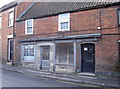
Shut up shop
Another commercial premises in Westbury that has fallen by the wayside.
Image: © Neil Owen
Taken: 26 Feb 2014
0.01 miles
3
![Westbury houses [54]](https://s0.geograph.org.uk/geophotos/06/83/35/6833592_166af1b6_120x120.jpg)
Westbury houses [54]
Even numbers 6 to 12 Fore Street are a terrace of four 18th century cottages with later alterations. Built of brick, now pebbledashed, on a stone plinth with an old tile roof. The fenestration has been altered and a late 19th century shop front to number 8 has been removed. Listed, grade II, with details at: https://historicengland.org.uk/listing/the-list/list-entry/1036294
Fore Street suffers from being part of the busy A350 which runs through the town with a constant stream of heavy goods vehicles.
Westbury is a former market town in the far west of Wiltshire under the north western edge of Salisbury Plain, 4 miles south of Trowbridge and 4 miles north of Warminster. Westbury was a centre of the cloth industry from the later 15th century until the 19th century. Malting was another important industry. There are now a number of large industrial and trading estates around the town with many residents working there. The town is an important junction point on the railway network with the Reading to Taunton line intersecting the line from Bristol to Southampton.
Image: © Michael Dibb
Taken: 29 Apr 2021
0.02 miles
4
![Westbury houses [56]](https://s3.geograph.org.uk/geophotos/06/83/36/6833603_a45a1420_120x120.jpg)
Westbury houses [56]
Numbers 14, 16 and 18 Fore Street are three 18th century cottages in a row. Constructed of brick with a concrete tile roof. Number 18 had a shop front, now removed. Listed, grade II, with details at: https://historicengland.org.uk/listing/the-list/list-entry/1036295
Fore Street suffers from being part of the busy A350 which runs through the town with a constant stream of heavy goods vehicles.
Westbury is a former market town in the far west of Wiltshire under the north western edge of Salisbury Plain, 4 miles south of Trowbridge and 4 miles north of Warminster. Westbury was a centre of the cloth industry from the later 15th century until the 19th century. Malting was another important industry. There are now a number of large industrial and trading estates around the town with many residents working there. The town is an important junction point on the railway network with the Reading to Taunton line intersecting the line from Bristol to Southampton.
Image: © Michael Dibb
Taken: 29 Apr 2021
0.02 miles
5
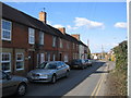
A350 Fore Street, Westbury
Towards Trowbridge.
Image: © Robin Webster
Taken: 30 May 2021
0.02 miles

7

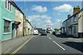
The Ludlow Arms, Westbury
Town centre pub at 19 Market Place. The street name sign a few metres beyond the far edge of the pub shows Fore Street.
Image: © Jaggery
Taken: 8 Mar 2014
0.03 miles
8
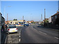
Trowbridge Road
A view looking north from the end of Fore Street towards the junction of Frogmore (left) with the A350 Trowbridge Road.
Image: © Phil Williams
Taken: 28 Jan 2006
0.04 miles
9
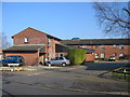
Bell Orchard
A view looking east across Field Close to the entrance to Bell Orchard, a sheltered housing complex.
Image: © Phil Williams
Taken: 28 Jan 2006
0.04 miles
10
Frogmore Road
A view looking north along Frogmore Road.
Image: © Phil Williams
Taken: 25 Feb 2006
0.04 miles