IMAGES TAKEN NEAR TO
White Horse Way, WESTBURY, BA13 3AS
Introduction
This page details the photographs taken nearby to White Horse Way, BA13 3AS by members of the Geograph project.
The Geograph project started in 2005 with the aim of publishing, organising and preserving representative images for every square kilometre of Great Britain, Ireland and the Isle of Man.

There are currently over 7.5m images from over14,400 individuals and you can help contribute to the project by visiting https://www.geograph.org.uk
Image Map (Loading...)


Getting Data...Please wait
Leaflet Map data © OpenStreetMap
Images are licensed for reuse under creativecommons.org/licenses/by-sa/2.0
Notes
- Clicking on the map will re-center to the selected point.
- The higher the marker number, the further away the image location is from the centre of the postcode.
Image Listing (438 Images Found)
Images are licensed for reuse under creativecommons.org/licenses/by-sa/2.0
Image
Details
Distance
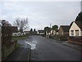
1

Watersmead
A view looking northwest to the entrance to Watersmead retirement bungalows.
Image: © Phil Williams
Taken: 28 Jan 2006
0.02 miles
2
![Westbury houses [63]](https://s2.geograph.org.uk/geophotos/06/83/45/6834534_64ab3e09_120x120.jpg)
Westbury houses [63]
Fatts Passage runs at right angles to West End behind number 24 West End. Numbers 2 and 3 Fatts Passage are late 17th or early 18th century, numbers 4 and 5 are probably later. Built in brick, now rendered, under a tiled roof. Listed, grade II, with details at: https://historicengland.org.uk/listing/the-list/list-entry/1036332
West End suffers from being part of the busy A350 which runs through the town with a constant stream of heavy goods vehicles.
Westbury is a former market town in the far west of Wiltshire under the north western edge of Salisbury Plain, 4 miles south of Trowbridge and 4 miles north of Warminster. Westbury was a centre of the cloth industry from the later 15th century until the 19th century. Malting was another important industry. There are now a number of large industrial and trading estates around the town with many residents working there. The town is an important junction point on the railway network with the Reading to Taunton line intersecting the line from Bristol to Southampton.
Image: © Michael Dibb
Taken: 29 Apr 2021
0.02 miles
3
![Westbury buildings [44]](https://s0.geograph.org.uk/geophotos/06/83/45/6834540_e9e7b9b6_120x120.jpg)
Westbury buildings [44]
Numbers 28 and 30 West End are 17th or early 18th century with later alterations. Built of brick, now rendered, with a pantile roof. Number 28 is the former Wheatsheaf public house, number 30 was a butchers shop. Listed, grade II, with details at: https://historicengland.org.uk/listing/the-list/list-entry/1364372
West End suffers from being part of the busy A350 which runs through the town with a constant stream of heavy goods vehicles.
Westbury is a former market town in the far west of Wiltshire under the north western edge of Salisbury Plain, 4 miles south of Trowbridge and 4 miles north of Warminster. Westbury was a centre of the cloth industry from the later 15th century until the 19th century. Malting was another important industry. There are now a number of large industrial and trading estates around the town with many residents working there. The town is an important junction point on the railway network with the Reading to Taunton line intersecting the line from Bristol to Southampton.
Image: © Michael Dibb
Taken: 29 Apr 2021
0.03 miles
4
![Westbury houses [64]](https://s2.geograph.org.uk/geophotos/06/83/45/6834538_21217c75_120x120.jpg)
Westbury houses [64]
Number 24 West End is probably 18th century built in brick, now rendered with stone quoins and cornice under a Roman tile roof. The doorway leads through to Fatts Passage and a rear extension links to number 2 Fatts Passage. Listed, grade II, with details at: https://historicengland.org.uk/listing/the-list/list-entry/1181570.
West End suffers from being part of the busy A350 which runs through the town with a constant stream of heavy goods vehicles.
Westbury is a former market town in the far west of Wiltshire under the north western edge of Salisbury Plain, 4 miles south of Trowbridge and 4 miles north of Warminster. Westbury was a centre of the cloth industry from the later 15th century until the 19th century. Malting was another important industry. There are now a number of large industrial and trading estates around the town with many residents working there. The town is an important junction point on the railway network with the Reading to Taunton line intersecting the line from Bristol to Southampton.
Image: © Michael Dibb
Taken: 29 Apr 2021
0.04 miles
5
![Westbury houses [65]](https://s3.geograph.org.uk/geophotos/06/83/45/6834539_eccb641e_120x120.jpg)
Westbury houses [65]
Number 26 West End is probably 18th century in red brick on a stone plinth under a Roman tile roof. There is one blind window above the doorway. Listed, grade II, with details at: https://historicengland.org.uk/listing/the-list/list-entry/1284926
West End suffers from being part of the busy A350 which runs through the town with a constant stream of heavy goods vehicles.
Westbury is a former market town in the far west of Wiltshire under the north western edge of Salisbury Plain, 4 miles south of Trowbridge and 4 miles north of Warminster. Westbury was a centre of the cloth industry from the later 15th century until the 19th century. Malting was another important industry. There are now a number of large industrial and trading estates around the town with many residents working there. The town is an important junction point on the railway network with the Reading to Taunton line intersecting the line from Bristol to Southampton.
Image: © Michael Dibb
Taken: 29 Apr 2021
0.04 miles
6
Field Close
A view looking north along Field Close at its junction with Downsview Road on a damp January morning.
Image: © Phil Williams
Taken: 14 Jan 2006
0.04 miles
7

Field Close
A view looking southeast along Field Close. the tower of All Saints church can be seen in the background.
Image: © Phil Williams
Taken: 14 Jan 2006
0.04 miles
8
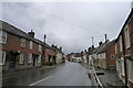
West End, Westbury
The A350 main road through the town.
Image: © Tim Heaton
Taken: 18 May 2021
0.04 miles
9
![Westbury houses [62]](https://s2.geograph.org.uk/geophotos/06/83/45/6834526_7d204a68_120x120.jpg)
Westbury houses [62]
Numbers 20 and 22 West End are early 19th century. The houses have been cement rendered with vermiculated quoins on the first storey. The roof is Roman tile. The door on the left leads to a through passage. Listed, grade II, with details at: https://historicengland.org.uk/listing/the-list/list-entry/1036331
West End suffers from being part of the busy A350 which runs through the town with a constant stream of heavy goods vehicles.
Westbury is a former market town in the far west of Wiltshire under the north western edge of Salisbury Plain, 4 miles south of Trowbridge and 4 miles north of Warminster. Westbury was a centre of the cloth industry from the later 15th century until the 19th century. Malting was another important industry. There are now a number of large industrial and trading estates around the town with many residents working there. The town is an important junction point on the railway network with the Reading to Taunton line intersecting the line from Bristol to Southampton.
Image: © Michael Dibb
Taken: 29 Apr 2021
0.04 miles
10
![Westbury buildings [43]](https://s2.geograph.org.uk/geophotos/06/83/45/6834518_7300977e_120x120.jpg)
Westbury buildings [43]
This large property at number 19 West End is seriously in need of maintenance. It is possibly timber framed and probably earlier than its apparent 18th century appearance. Built of brick, now rendered, under a tile roof. The shop front is late 19th century and there is a lean-to garage on the sight. Listed, grade II, with details at: https://historicengland.org.uk/listing/the-list/list-entry/1284953
West End suffers from being part of the busy A350 which runs through the town with a constant stream of heavy goods vehicles.
Westbury is a former market town in the far west of Wiltshire under the north western edge of Salisbury Plain, 4 miles south of Trowbridge and 4 miles north of Warminster. Westbury was a centre of the cloth industry from the later 15th century until the 19th century. Malting was another important industry. There are now a number of large industrial and trading estates around the town with many residents working there. The town is an important junction point on the railway network with the Reading to Taunton line intersecting the line from Bristol to Southampton.
Image: © Michael Dibb
Taken: 29 Apr 2021
0.04 miles