IMAGES TAKEN NEAR TO
Morgan Walk, WESTBURY, BA13 2GW
Introduction
This page details the photographs taken nearby to Morgan Walk, BA13 2GW by members of the Geograph project.
The Geograph project started in 2005 with the aim of publishing, organising and preserving representative images for every square kilometre of Great Britain, Ireland and the Isle of Man.

There are currently over 7.5m images from over14,400 individuals and you can help contribute to the project by visiting https://www.geograph.org.uk
Image Map
Images are licensed for reuse under creativecommons.org/licenses/by-sa/2.0
Notes
- Clicking on the map will re-center to the selected point.
- The higher the marker number, the further away the image location is from the centre of the postcode.
Image Listing (12 Images Found)
Images are licensed for reuse under creativecommons.org/licenses/by-sa/2.0
Image
Details
Distance
1
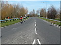
Mane Way cyclists, Westbury
Viewed from the roundabout at the A3098 junction, looking NNE.
Image: © Jaggery
Taken: 8 Mar 2014
0.19 miles
2
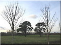
Trees, old and new
A view looking to the northwest across an open area at Leigh Park, showing two old yew trees framed by new saplings planted as part of the housing development.
Image: © Phil Williams
Taken: 17 Jan 2006
0.20 miles
3
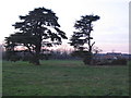
Storm damage
A view looking to the northwest across an open area at Leigh Park, showing the two yew trees, one of which has been damaged by recent high winds.
Image: © Phil Williams
Taken: 4 Feb 2007
0.20 miles
4
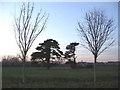
Storm damaged yew
A view looking to the northwest across an open area at Leigh Park, showing one of the two yew trees damaged by recent high winds.
Image: © Phil Williams
Taken: 4 Feb 2007
0.20 miles
5
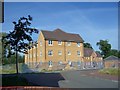
New housing next to Tesco Express, Leigh Park, Westbury
New accommodation being built next to the Leigh Park Local Centre, Westbury.
Image: © Philip Reed
Taken: 20 Sep 2008
0.22 miles
6
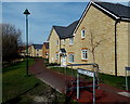
Pinto Walk, Westbury
21st century housing on the north side of Leigh Park Way.
Image: © Jaggery
Taken: 8 Mar 2014
0.22 miles
7
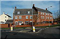
Mustang Close, Westbury
Housing at the southern edge of Mustang Close, viewed across Leigh Park Way.
Image: © Jaggery
Taken: 8 Mar 2014
0.23 miles
8

Criollo Court, Westbury
Flats near Palomino Place shops http://www.geograph.org.uk/photo/3905332
Westbury is most famous for the Westbury White Horse, a large figure on a hill at the edge of Bratton Downs. The horsy theme was used for some of the names in this area. A palomino is a horse with a light golden-brown coat and white or pale mane and tail. A criollo is a small horse bred from South American and Arab stock.
Image: © Jaggery
Taken: 8 Mar 2014
0.23 miles
9

Willoughby Close, Westbury
Viewed across Leigh Park Way.
Image: © Jaggery
Taken: 8 Mar 2014
0.24 miles
10
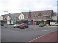
Local Centre, Leigh Park, Westbury
This is the parade of shops at Leigh Park Local Centre, part of the Leigh Park development, a new neighbourhood next to Westbury Leigh in Westbury.
The road is called Palamino Place.
Leigh Park Community Centre, Leigh Park Doctors' Surgery and Leigh Park Community Nursery are expected to be built on adjacent land to the right of the shop shortly. Together with the shops, these buildings form Leigh Park Local Centre.
Image: © Phil Williams
Taken: 13 Nov 2005
0.24 miles