IMAGES TAKEN NEAR TO
Rivers Street Place, BATH, BA1 2RS
Introduction
This page details the photographs taken nearby to Rivers Street Place, BA1 2RS by members of the Geograph project.
The Geograph project started in 2005 with the aim of publishing, organising and preserving representative images for every square kilometre of Great Britain, Ireland and the Isle of Man.

There are currently over 7.5m images from over14,400 individuals and you can help contribute to the project by visiting https://www.geograph.org.uk
Image Map
Images are licensed for reuse under creativecommons.org/licenses/by-sa/2.0
Notes
- Clicking on the map will re-center to the selected point.
- The higher the marker number, the further away the image location is from the centre of the postcode.
Image Listing (777 Images Found)
Images are licensed for reuse under creativecommons.org/licenses/by-sa/2.0
Image
Details
Distance
1
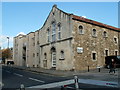
Jaguar House and Christchurch Hall, Bath
Viewed across Julian Road opposite Christ Church. http://www.geograph.org.uk/photo/3204656
Jaguar House is on the left. Christchurch Hall is on the right.
Image: © Jaggery
Taken: 24 Sep 2011
0.02 miles
2

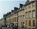
16-26 Rivers Street, Bath
Much of the eastern terrace on the north side of the street, designed by John Wood the Younger from 1770. Characteristic three-bay houses, here all accorded a pedimented Doric doorcase. Grade II listed.
Image: © Stephen Richards
Taken: 25 May 2012
0.02 miles
3
Julian Road
This shows two of the three churches on the north side of the road: St. Mary's Catholic Church near left and Christ Church in the distance. The hill begins to flatten out here so there is more space to put up large buildings.
Image: © HelenK
Taken: 8 Jun 2007
0.04 miles
4

Museum of Bath at Work, Julian Road, Bath
Built as a royal tennis court by Richard Scrase, 1777, and a museum since 1969. Grade II listed.
"The centrepiece of the Museum, covering an entire floor, is the reconstructed engineering and soft drinks factory of Victorian businessman J B Bowler."
Image: © Stephen Richards
Taken: 25 May 2012
0.04 miles
5
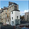
Corner of Rivers Street and Julian Road, Bath
The small white house, number 31A Rivers Street, looks like a later addition
to the row of houses, a supposition supported by the A suffix in its number.
Behind it and above it, there is a faded inscription on the side wall
of number 31 Rivers Street. It is ESTD. 1798 OLD RED HOUSE RIVERS STREET.
Image: © Jaggery
Taken: 24 Sep 2011
0.04 miles
6
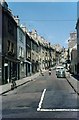
Morford Street, Bath, 1966
It took me some time to identify this street (which was mis-named in my index) because much of it has been demolished and replaced by modern buildings https://goo.gl/maps/pVCcogJ7wSHA69zZ9 . The remaining old buildings on the left hand side were built between 1775 and 1789 and are individually Listed Grade II.
Image: © Alan Murray-Rust
Taken: 18 Jul 1966
0.05 miles
7

1-15 Rivers Street, Bath
Another product of John Wood the Younger's office. This group dates from c1770. The first four are unusual in having tripartite windows; the rest are more conventional (e.g. Image]). Some good pedimented doorcases in evidence. Grade II listed.
Image: © Stephen Richards
Taken: 25 May 2012
0.05 miles
8
1-8 Russell Street, Bath
The terraces in this and surrounding streets were designed by John Wood the Younger. The street was laid out in 1770-76. Typical, as in three bays and moulded window architraves. Plain but dignified. Grade II listed.
Image: © Stephen Richards
Taken: 25 May 2012
0.05 miles
9

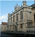
Tower of Christ Church, Bath
Christ Church is an Anglican church in the diocese of Bath and Wells.
The church was consecrated in November 1798.
This view is across Julian Road, from the corner of Rivers Street.
Image: © Jaggery
Taken: 24 Sep 2011
0.05 miles
10
South side of Christ Church, Bath
Viewed across Julian Road. The church tower http://www.geograph.org.uk/photo/3204656 is in the background.
Christ Church is an Anglican church in the diocese of Bath and Wells.
The church was consecrated in November 1798.
Image: © Jaggery
Taken: 24 Sep 2011
0.05 miles