IMAGES TAKEN NEAR TO
Nettlemead Lane, WARMINSTER, BA12 0RS
Introduction
This page details the photographs taken nearby to Nettlemead Lane, BA12 0RS by members of the Geograph project.
The Geograph project started in 2005 with the aim of publishing, organising and preserving representative images for every square kilometre of Great Britain, Ireland and the Isle of Man.

There are currently over 7.5m images from over14,400 individuals and you can help contribute to the project by visiting https://www.geograph.org.uk
Image Map
Images are licensed for reuse under creativecommons.org/licenses/by-sa/2.0
Notes
- Clicking on the map will re-center to the selected point.
- The higher the marker number, the further away the image location is from the centre of the postcode.
Image Listing (9 Images Found)
Images are licensed for reuse under creativecommons.org/licenses/by-sa/2.0
Image
Details
Distance
1
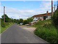
Wilton Road, Wylye
The lane for Hanging Langford passing Chequers Cottages.
Image: © Andrew Smith
Taken: 8 Jul 2007
0.07 miles
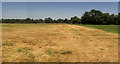
2
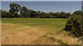
Field near Wylye
Looking right from where Image] was taken, with a line of trees along a drainage channel on the Wylye flood plain.
Image: © Derek Harper
Taken: 30 Jun 2018
0.08 miles
3
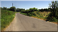
Wilton Road, Wylye
Followed by the NCN24; the road provides a more peaceful alternative along the Wylye valley to the A36, which runs along the other side of the valley.
Image: © Derek Harper
Taken: 30 Jun 2018
0.13 miles
4
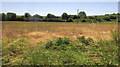
Field near Wylye
On the other side of Wilton Road from Image] and Image On the far side is the railway embankment carrying the Salisbury branch line to Westbury.
Image: © Derek Harper
Taken: 30 Jun 2018
0.13 miles
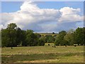
5
Farmland near Wylye
Looking right from where Image] was taken, across the flood plain of the River Wylye, which is 300 metres away.
Image: © Derek Harper
Taken: 30 Jun 2018
0.18 miles
6
Wilton Road, Wylye
A pair of cyclists on NCN24, which uses this lane between Wilton and Wylye along the southern side of the Wylye valley.
Image: © Derek Harper
Taken: 30 Jun 2018
0.18 miles
7
![Wylye features [2]](https://s2.geograph.org.uk/geophotos/07/18/43/7184362_8a74da87_120x120.jpg)
Wylye features [2]
Seen from the level crossing of Dinton Road is the lines of the Salisbury branch line, looking towards Salisbury. The Great Western Railway line runs from Westbury to Salisbury as part of the Wessex Main Line.
The village of Wylye is located halfway between Salisbury and Warminster, some 9½ miles (15 kilometres) from both. The village is astride the River Wylye and is just south of the major road intersection with the junction of the A36 and the A303. Within the wider area Bronze Age artefacts have been found, there is an Iron Age hill fort and a Roman Road runs east to west.
Image: © Michael Dibb
Taken: 20 Apr 2022
0.20 miles
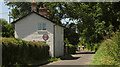
8
Pastures, Wylye
Looking towards the river from the road to Hanging Langford.
Image: © Andrew Smith
Taken: 8 Jul 2007
0.22 miles
9
![Wylye houses [3]](https://s0.geograph.org.uk/geophotos/07/18/43/7184360_177f5c33_120x120.jpg)
Wylye houses [3]
Court Farmhouse, Wilton Road, was built in the early 19th century and was extended in the late 19th century. The front is ashlar, the other walls are chalk and brick, all under a Welsh slate hipped roof. There is a cast-iron handrail and fine double gates. Listed, grade II, with details at: https://historicengland.org.uk/listing/the-list/list-entry/1318749
The village of Wylye is located halfway between Salisbury and Warminster, some 9½ miles (15 kilometres) from both. The village is astride the River Wylye and is just south of the major road intersection with the junction of the A36 and the A303. Within the wider area Bronze Age artefacts have been found, there is an Iron Age hill fort and a Roman Road runs east to west.
Image: © Michael Dibb
Taken: 20 Apr 2022
0.24 miles