IMAGES TAKEN NEAR TO
Dinton Road, WARMINSTER, BA12 0RB
Introduction
This page details the photographs taken nearby to Dinton Road, BA12 0RB by members of the Geograph project.
The Geograph project started in 2005 with the aim of publishing, organising and preserving representative images for every square kilometre of Great Britain, Ireland and the Isle of Man.

There are currently over 7.5m images from over14,400 individuals and you can help contribute to the project by visiting https://www.geograph.org.uk
Image Map
Images are licensed for reuse under creativecommons.org/licenses/by-sa/2.0
Notes
- Clicking on the map will re-center to the selected point.
- The higher the marker number, the further away the image location is from the centre of the postcode.
Image Listing (5 Images Found)
Images are licensed for reuse under creativecommons.org/licenses/by-sa/2.0
Image
Details
Distance
1
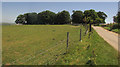
Trees, Bilbury Farm
Bilbury Rings surround the farm and trees, and one earthwork rampart is visible on the left in front of the trees. "Iron Age multivallate hillfort enclosing an area of 17.5 acres ... The hillfort encloses an irregular-shaped area and was late Iron Age and Roman in date". http://www.pastscape.org.uk/hob.aspx?hob_id=214484&sort=2&type=hillfort&rational=a&class1=None&period=None&county=None&district=None&parish=None&place=&recordsperpage=10&source=text&rtype=&rnumber=&p=87&move=n&nor=889&recfc=0 .
Image: © Derek Harper
Taken: 30 Jun 2018
0.08 miles
2
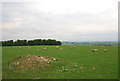
Bilbury Rings
Sheep pasture land. Not convinced that the mound in the foreground really relates to the rings which are only barely discernible as indentations in the ground.
Image: © Toby
Taken: 26 May 2007
0.12 miles
3
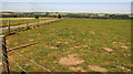
Pasture at Bilbury Farm
Looking left from Image], with Dinton Road, leading down into Wylye.
Image: © Derek Harper
Taken: 30 Jun 2018
0.19 miles
4
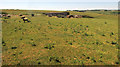
Barn, Bilbury Farm
Looking left from where Image] was taken, with sheep. Much of Wylye Cow Down Bottom, the fry valley beyond the farm, forms Wylye Down National Nature Reserve.
Image: © Derek Harper
Taken: 30 Jun 2018
0.20 miles
5
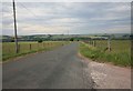
The Dinton to Wylye road
Looking towards Wylye village the road drops down from the plain into the valley.
Image: © roger geach
Taken: 1 Jul 2010
0.20 miles