IMAGES TAKEN NEAR TO
Wylye, WARMINSTER, BA12 0QY
Introduction
This page details the photographs taken nearby to BA12 0QY by members of the Geograph project.
The Geograph project started in 2005 with the aim of publishing, organising and preserving representative images for every square kilometre of Great Britain, Ireland and the Isle of Man.

There are currently over 7.5m images from over14,400 individuals and you can help contribute to the project by visiting https://www.geograph.org.uk
Image Map
Images are licensed for reuse under creativecommons.org/licenses/by-sa/2.0
Notes
- Clicking on the map will re-center to the selected point.
- The higher the marker number, the further away the image location is from the centre of the postcode.
Image Listing (137 Images Found)
Images are licensed for reuse under creativecommons.org/licenses/by-sa/2.0
Image
Details
Distance
1
![Wylye houses [2]](https://s3.geograph.org.uk/geophotos/07/18/43/7184359_80703db2_120x120.jpg)
Wylye houses [2]
Elmbury Cottage, Sheepwash Lane, is an early 17th century detached cottage, extended in the late 17th century. Constructed of banded flint and limestone under a thatch roof. Some original internal features remain. Listed, grade II, with details at: https://historicengland.org.uk/listing/the-list/list-entry/1198026
The village of Wylye is located halfway between Salisbury and Warminster, some 9½ miles (15 kilometres) from both. The village is astride the River Wylye and is just south of the major road intersection with the junction of the A36 and the A303. Within the wider area Bronze Age artefacts have been found, there is an Iron Age hill fort and a Roman Road runs east to west.
Image: © Michael Dibb
Taken: 20 Apr 2022
0.03 miles
2
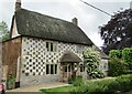
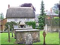
Wylye - Thatched Cottage
Eye catching historic thatched cottage with chequerboard stonework.
Image: © Colin Smith
Taken: 14 Jun 2019
0.06 miles
3
![Wylye houses [4]](https://s2.geograph.org.uk/geophotos/07/18/43/7184366_fd4bba0f_120x120.jpg)
Wylye houses [4]
Walnut Cottage, Fore Street, is a late 17th century detached cottage. There is a 19th century rear extension. Constructed of chequered flint and limestone under a thatch roof. Listed, grade II, with details at: https://historicengland.org.uk/listing/the-list/list-entry/1146211
The village of Wylye is located halfway between Salisbury and Warminster, some 9½ miles (15 kilometres) from both. The village is astride the River Wylye and is just south of the major road intersection with the junction of the A36 and the A303. Within the wider area Bronze Age artefacts have been found, there is an Iron Age hill fort and a Roman Road runs east to west.
Image: © Michael Dibb
Taken: 20 Apr 2022
0.06 miles
4
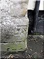
Bench Mark, East Farm
The bench mark is to be found on the north west angle of the farm building. For a view of the wall Image and for further information on the bench mark and others in the area http://www.bench-marks.org.uk/bm37317
Image: © Maigheach-gheal
Taken: 16 Mar 2011
0.08 miles
5
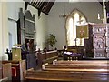
Interior, Church of St Mary the Virgin, Wylye
The organ was installed in 1876 and was made by Allen and Co of Bristol.
Image: © Maigheach-gheal
Taken: 29 Jun 2008
0.08 miles
6
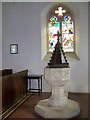
Font, Church of St Mary the Virgin, Wylye
The font was given shortly after the restoration work was carried out.
Image: © Maigheach-gheal
Taken: 29 Jun 2008
0.08 miles
7
![Parish church [4]](https://s0.geograph.org.uk/geophotos/07/18/43/7184352_d6931382_120x120.jpg)
Parish church [4]
Part of the churchyard.
The Anglican parish church of St Mary, was rebuilt in 1846 with only the tower and the walls of the chancel retained from the earlier building. The chancel is 13th century, the tower 15th century. Constructed of squared, coursed limestone and flint under a tile roof. Listed, grade II*, with details at: https://historicengland.org.uk/listing/the-list/list-entry/1146203
The village of Wylye is located halfway between Salisbury and Warminster, some 9½ miles (15 kilometres) from both. The village is astride the River Wylye and is just south of the major road intersection with the junction of the A36 and the A303. Within the wider area Bronze Age artefacts have been found, there is an Iron Age hill fort and a Roman Road runs east to west.
Image: © Michael Dibb
Taken: 20 Apr 2022
0.08 miles
8
Tombs, Church of St Mary the Virgin, Wylye
Some of the gravestones and tombs are of good design and workmanship, and many date back to the seventeenth, eighteenth and nineteenth centuries. They are mainly of stone from the nearby quarries of Chilmark and Tisbury.
Image: © Maigheach-gheal
Taken: 29 Jun 2008
0.09 miles
9
![Wylye houses [1]](https://s0.geograph.org.uk/geophotos/07/18/43/7184356_2b74ebaa_120x120.jpg)
Wylye houses [1]
Number 1 Church Street is a late 17th century detached cottage. Constructed of chequered flint and chalk under a thatch roof. On the left is a lean-to 20th century weatherboarded garage. On the right is a 19th century extension in rubble stone. Listed, grade II, with details at: https://historicengland.org.uk/listing/the-list/list-entry/1318727
The village of Wylye is located halfway between Salisbury and Warminster, some 9½ miles (15 kilometres) from both. The village is astride the River Wylye and is just south of the major road intersection with the junction of the A36 and the A303. Within the wider area Bronze Age artefacts have been found, there is an Iron Age hill fort and a Roman Road runs east to west.
Image: © Michael Dibb
Taken: 20 Apr 2022
0.09 miles
10
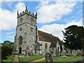
Wylye - Parish Church
St Mary the Virgin is a Grade II listed building, has 13th-century origins but was rebuilt in 1846 to designs by T.H. Wyatt and D. Brandon.
Image: © Colin Smith
Taken: 14 Jun 2019
0.09 miles