IMAGES TAKEN NEAR TO
Chitterne, WARMINSTER, BA12 0LG
Introduction
This page details the photographs taken nearby to BA12 0LG by members of the Geograph project.
The Geograph project started in 2005 with the aim of publishing, organising and preserving representative images for every square kilometre of Great Britain, Ireland and the Isle of Man.

There are currently over 7.5m images from over14,400 individuals and you can help contribute to the project by visiting https://www.geograph.org.uk
Image Map
Images are licensed for reuse under creativecommons.org/licenses/by-sa/2.0
Notes
- Clicking on the map will re-center to the selected point.
- The higher the marker number, the further away the image location is from the centre of the postcode.
Image Listing (118 Images Found)
Images are licensed for reuse under creativecommons.org/licenses/by-sa/2.0
Image
Details
Distance
1
![Chitterne houses [26]](https://s3.geograph.org.uk/geophotos/06/39/87/6398783_b9cd195d_120x120.jpg)
Chitterne houses [26]
The early 19th century The Grange with its gable end to the road. See also Image Listed, grade II, with details at: https://historicengland.org.uk/listing/the-list/list-entry/1036440
Chitterne village lies in the middle of Salisbury Plain. Much of the parish is owned by the Ministry of Defence within the Salisbury Plain Training Area. The Imber firing range is to the north and the Copehill Down training area to the east. The Chitterne Brook, a small tributary of the River Wylye, flows through the village. There is a fine history of the village at: http://www.chitterne.com/history/index.html
Image: © Michael Dibb
Taken: 29 Jan 2020
0.03 miles
2
![Chitterne houses [15]](https://s0.geograph.org.uk/geophotos/06/39/80/6398028_045d635a_120x120.jpg)
Chitterne houses [15]
A glimpse over the garden wall of the early 19th century The Grange with its gable end to the road. See also Image Listed, grade II, with details at: https://historicengland.org.uk/listing/the-list/list-entry/1036440
Chitterne village lies in the middle of Salisbury Plain. Much of the parish is owned by the Ministry of Defence within the Salisbury Plain Training Area. The Imber firing range is to the north and the Copehill Down training area to the east. The Chitterne Brook, a small tributary of the River Wylye, flows through the village. There is a fine history of the village at: http://www.chitterne.com/history/index.html
Image: © Michael Dibb
Taken: 29 Jan 2020
0.03 miles
3

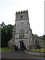
The Church of All Saints & St Mary, Chitterne - Tower
Image: © Maigheach-gheal
Taken: 20 Mar 2007
0.04 miles
5
![Chitterne ways [6]](https://s2.geograph.org.uk/geophotos/06/39/80/6398026_872347b6_120x120.jpg)
Chitterne ways [6]
The bridge over Chitterne Brook gives access to the public footpath which runs alongside the far side of the brook. Another footpath leads to The Manor and St Marys.
Chitterne village lies in the middle of Salisbury Plain. Much of the parish is owned by the Ministry of Defence within the Salisbury Plain Training Area. The Imber firing range is to the north and the Copehill Down training area to the east. The Chitterne Brook, a small tributary of the River Wylye, flows through the village. There is a fine history of the village at: http://www.chitterne.com/history/index.html
Image: © Michael Dibb
Taken: 29 Jan 2020
0.05 miles
6
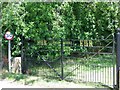
Gates, Chitterne
The gates to the churchyard of All Saints & St Mary were erected to celebrate the Golden Jubilee of HM Queen Elizabeth II.
Image: © Maigheach-gheal
Taken: 18 Jul 2010
0.05 miles
7
![Chitterne houses [16]](https://s3.geograph.org.uk/geophotos/06/39/80/6398031_caa1ec68_120x120.jpg)
Chitterne houses [16]
Seen here from the road to the south, The Gatehouse is late 16th and late 17th century with 20th century alterations. The building is a mixture of chequered limestone and flint, brick and timber framed. The timber framed 16th century part is possibly the remains of a larger wing. Some original internal features remain. The listing includes the gate piers and the wall which is integral with the 17th century build. Listed, grade II*, with details at: https://historicengland.org.uk/listing/the-list/list-entry/1364348
Chitterne village lies in the middle of Salisbury Plain. Much of the parish is owned by the Ministry of Defence within the Salisbury Plain Training Area. The Imber firing range is to the north and the Copehill Down training area to the east. The Chitterne Brook, a small tributary of the River Wylye, flows through the village. There is a fine history of the village at: http://www.chitterne.com/history/index.html
Image: © Michael Dibb
Taken: 29 Jan 2020
0.05 miles
8
![Chitterne houses [17]](https://s0.geograph.org.uk/geophotos/06/39/80/6398032_58ae050f_120x120.jpg)
Chitterne houses [17]
A closer look at The Gatehouse which is late 16th and late 17th century with 20th century alterations. The building is a mixture of chequered limestone and flint, brick and timber framed. The timber framed 16th century part is possibly the remains of a larger wing. Some original internal features remain. The listing includes the gate piers and the wall which is integral with the 17th century build. Listed, grade II*, with details at: https://historicengland.org.uk/listing/the-list/list-entry/1364348
Chitterne village lies in the middle of Salisbury Plain. Much of the parish is owned by the Ministry of Defence within the Salisbury Plain Training Area. The Imber firing range is to the north and the Copehill Down training area to the east. The Chitterne Brook, a small tributary of the River Wylye, flows through the village. There is a fine history of the village at: http://www.chitterne.com/history/index.html
Image: © Michael Dibb
Taken: 29 Jan 2020
0.05 miles
9

The Church of All Saints & St Mary, Chitterne
A Victorian building by the architect T H Wyatt, the Salisbury diocesan architect.
Image: © Maigheach-gheal
Taken: 20 Mar 2007
0.05 miles
10
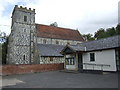
Chitterne parish church and village hall
Image: © Jonathan Billinger
Taken: 29 Aug 2007
0.05 miles