IMAGES TAKEN NEAR TO
Salisbury Road, WARMINSTER, BA12 0JJ
Introduction
This page details the photographs taken nearby to Salisbury Road, BA12 0JJ by members of the Geograph project.
The Geograph project started in 2005 with the aim of publishing, organising and preserving representative images for every square kilometre of Great Britain, Ireland and the Isle of Man.

There are currently over 7.5m images from over14,400 individuals and you can help contribute to the project by visiting https://www.geograph.org.uk
Image Map
Images are licensed for reuse under creativecommons.org/licenses/by-sa/2.0
Notes
- Clicking on the map will re-center to the selected point.
- The higher the marker number, the further away the image location is from the centre of the postcode.
Image Listing (27 Images Found)
Images are licensed for reuse under creativecommons.org/licenses/by-sa/2.0
Image
Details
Distance
1
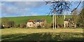
Upton Lovell, Wiltshire
Looking towards Knook Horse Hill from the north edge of the village of Upton Lovell.
Image: © Rebecca A Wills
Taken: 27 Dec 2020
0.07 miles
2
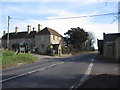
Junction for Upton Lovell
A view looking to the southeast along the A36 towards the junction of the lane to Upton Lovell. The small building on the left now used as a bus shelter may once have been a toll booth.
Image: © Phil Williams
Taken: 4 Feb 2007
0.08 miles
3
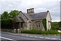
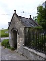
Old Toll House by the A36, Upton Folly
Codford Toll House (and weigh engine) by the A36, in parish of Upton Lovell (West Wiltshire District), tollhouse, Manor Road junction (Stone hut opposite is WI.ULOH Image).
Grade II listed together with shelter opposite.
List Entry Number: 1422057 https://historicengland.org.uk/listing/the-list/list-entry/1422057
Surveyed
Milestone Society National ID: WI.ULO
Image: © Alan Rosevear
Taken: 24 Jun 2013
0.10 miles
4
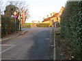
Road from Upton Lovell at its junction with the A36 at Upton Folly
Looking north-eastward.
Image: © Peter Wood
Taken: 13 Feb 2017
0.10 miles
5
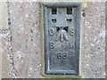
Ordnance Survey Flush Bracket 66
This can be found on the wall of a house - a private dwelling - at Upton Folly.
For more detail see : http://www.bench-marks.org.uk/bm2045
Image: © Peter Wood
Taken: 13 Feb 2017
0.10 miles
6
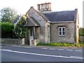
Old Toll House by the A36, Upton Folly
Codford Toll House (hut) by the A36, in parish of Upton Lovell (West Wiltshire District), bus shelter, Manor Road junction (toll house opposite is WI.ULO Image).
Grade II listed together with toll house opposite.
List Entry Number: 1422057 https://historicengland.org.uk/listing/the-list/list-entry/1422057
Surveyed
Milestone Society National ID: WI.ULOH
Image: © Alan Rosevear
Taken: 24 Jun 2013
0.10 miles
7
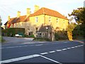
Toll house, Upton Lovell
This is the former toll house, designed by Mr Pinch of Bath and built by Mr William Trapp of Warminster in 1836. In the 1861 census the occupier was John Gibbs, a cloth dresser and his wife and family. On the closure of the turnpike in 1870, the house was offered for sale first to a Mr Everett but he declined it and the house was sold at auction.
Image: © Maigheach-gheal
Taken: 21 Sep 2009
0.10 miles
8
Bus shelter, Upton Lovell
The bus shelter is the former house of the turnpike weighing engine.
Image: © Maigheach-gheal
Taken: 21 Sep 2009
0.11 miles
9
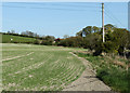
2011 : Fields north of Up Street, Upton Lovell
Autumn sown wheat in the near field in need of rain.
Image: © Maurice Pullin
Taken: 10 Apr 2011
0.12 miles
10
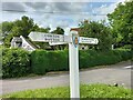
Direction Sign – Signpost at Upton Lovell
Located on a grass triangle in the centre of the junction of Lovel Road and Manor Road in Upton Lovell parish. 3 arms and pyramid top.
Milestone Society National ID: WI_ST9441
Image: © G Fawcett
Taken: 1 Jul 2023
0.13 miles