IMAGES TAKEN NEAR TO
FROME, BA11 9AE
Introduction
This page details the photographs taken nearby to BA11 9AE by members of the Geograph project.
The Geograph project started in 2005 with the aim of publishing, organising and preserving representative images for every square kilometre of Great Britain, Ireland and the Isle of Man.

There are currently over 7.5m images from over14,400 individuals and you can help contribute to the project by visiting https://www.geograph.org.uk
Image Map (Loading...)


Getting Data...Please wait
Leaflet Map data © OpenStreetMap
Images are licensed for reuse under creativecommons.org/licenses/by-sa/2.0
Notes
- Clicking on the map will re-center to the selected point.
- The higher the marker number, the further away the image location is from the centre of the postcode.
Image Listing (19 Images Found)
Images are licensed for reuse under creativecommons.org/licenses/by-sa/2.0
Image
Details
Distance
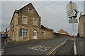
2
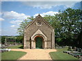
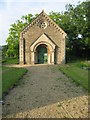
Frome Dissenters Cemetery Chapel
View of Chapel from Vallis Road
Image: © Jim Parsons
Taken: 26 Nov 2007
0.07 miles
3

2009 : A362 Vallis Road Frome
Less than a mile from the town centre.
The hill in the distance is Cley Hill near Warminster Image
Image: © Maurice Pullin
Taken: 8 Dec 2009
0.09 miles
4
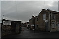
Henry Wells coal merchants, Frome
Open 9-2 on Saturdays for domestic solid fuel. Taken from the cab of my lorry (while parked!).
Image: © John Winder
Taken: 28 Jan 2015
0.14 miles
5
Robins Lane, Frome - another view
The site I was delivering to is on the left: the mirrors of my lorry are just visible! The red block marks the top of the first storey of the house which is being built on the site.
While Googling to find out something of the history of the area, I discovered that Robins Lane is 97.94 miles West of the centre of London, 19.03 miles South East of the centre of Bristol and approximately 18.69 miles from the sea (tidal high water mark). So now you know.
Image: © John Winder
Taken: 27 Jan 2015
0.14 miles
6
Robins Lane, Frome
Taken while I was delivering some wall panels to a house build site nearby: you can just see the cab of my lorry poking above the wall in the middle of the shot. Soon this view will change as a two storey house is erected in front of the gable end to the right of centre. When I arrived on Monday morning to deliver the wall panels, the house was no more than a concrete floor; by Wednesday, the walls had been erected and work had started on the upper storey.
Image: © John Winder
Taken: 27 Jan 2015
0.16 miles
7
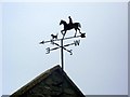
Weather vane, Frome
For centuries weathervanes have kept people in touch with the elements, signalling those shifts in the wind, which bring changes in the weather. This simple device has grown into an English tradition which can say something about their owners, adding interest to the landscape.
Image: © Maigheach-gheal
Taken: 18 Sep 2009
0.17 miles
8
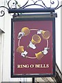
Sign for the Ring O' Bells
Often a name for a pub used by the local bell-ringers. The sign shows a set of hand-bells.
Image: © Maigheach-gheal
Taken: 18 Sep 2009
0.17 miles
9
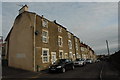
Horton Street, Frome
Built in the first half of the 18th Century as Frome expanded and demand for housing for the workers in the town's booming textile industry, Horton Street and other streets in this area are more properly part of the Newtown area of Frome. The road links Robin Street and Vallis Street.
Image: © John Winder
Taken: 27 Jan 2015
0.17 miles
10

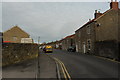
Street Scene, Frome
The road enters the town from the west.
Image: © Maigheach-gheal
Taken: 18 Sep 2009
0.19 miles