IMAGES TAKEN NEAR TO
Knoll Hill View, FROME, BA11 5DT
Introduction
This page details the photographs taken nearby to Knoll Hill View, BA11 5DT by members of the Geograph project.
The Geograph project started in 2005 with the aim of publishing, organising and preserving representative images for every square kilometre of Great Britain, Ireland and the Isle of Man.

There are currently over 7.5m images from over14,400 individuals and you can help contribute to the project by visiting https://www.geograph.org.uk
Image Map
Images are licensed for reuse under creativecommons.org/licenses/by-sa/2.0
Notes
- Clicking on the map will re-center to the selected point.
- The higher the marker number, the further away the image location is from the centre of the postcode.
Image Listing (17 Images Found)
Images are licensed for reuse under creativecommons.org/licenses/by-sa/2.0
Image
Details
Distance
1
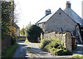
2010 : Westend Lane, the Trudoxhill bypass
According to OS Explorer 142 this is a "Byway open to all traffic." Wouldn't fancy it in my little C1 let alone a 40 ton artic with trailer.
Westend Farm is at this end of the lane, Cricket Farm at the other.
Image: © Maurice Pullin
Taken: 25 Oct 2010
0.03 miles
2
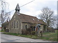
Old chapel at Knoll Hill
This former chapel at Knoll Hill now appears to be in use as a private residence. View looking northeast across the lane from Nunney to Trudoxhill.
Image: © Phil Williams
Taken: 12 Mar 2006
0.04 miles
3
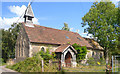
An Old Chapel
Looking a bit more overgrown than in this image from 2006 Image and the footpath sign has gone.
Image: © Des Blenkinsopp
Taken: 22 Aug 2014
0.06 miles
4
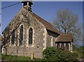
Former chapel near Trudoxhill
Now a private residence.
Image: © Graham Horn
Taken: 3 May 2007
0.06 miles
5
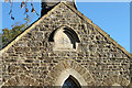
2010 : Detail on former chapel north of Trudoxhill
A search on WWW was unable to find the denomination of this former chapel.
Probably not Congregational.
My guess? Wesleyan or Baptist.
Image: © Maurice Pullin
Taken: 25 Oct 2010
0.07 miles
6
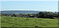
2010 : Looking over a grassy knoll toward Sunnyside Farm
An innocent pasture in fact.
Not sure which of these buildings is Sunnyside Farm.
Great Bradley Wood covers the hill in the distance.
Image: © Maurice Pullin
Taken: 25 Oct 2010
0.09 miles
7
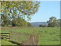
2010 : Looking east near Knoll Hill Farm
Standing on a stile at the end of a footpath crossing the field from the old chapel.
Image: © Maurice Pullin
Taken: 25 Oct 2010
0.12 miles
9
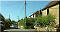
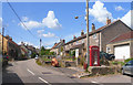
Macmillan Way in Trudoxhill
The LDP follows the main village street north-westwards. This was taken a little further up the road from Image
Image: © Derek Harper
Taken: 27 May 2022
0.14 miles
10
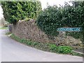
Foghamshire Lane, Trudoxhill
There was no particular reason to take a picture of this lane other than I like the name. It is part of the Macmillan Way.
Image: © Maigheach-gheal
Taken: 1 Mar 2009
0.19 miles