IMAGES TAKEN NEAR TO
Ashfield Close, FROME, BA11 5DQ
Introduction
This page details the photographs taken nearby to Ashfield Close, BA11 5DQ by members of the Geograph project.
The Geograph project started in 2005 with the aim of publishing, organising and preserving representative images for every square kilometre of Great Britain, Ireland and the Isle of Man.

There are currently over 7.5m images from over14,400 individuals and you can help contribute to the project by visiting https://www.geograph.org.uk
Image Map
Images are licensed for reuse under creativecommons.org/licenses/by-sa/2.0
Notes
- Clicking on the map will re-center to the selected point.
- The higher the marker number, the further away the image location is from the centre of the postcode.
Image Listing (13 Images Found)
Images are licensed for reuse under creativecommons.org/licenses/by-sa/2.0
Image
Details
Distance
1
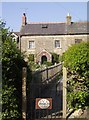
Cottages in Trudoxhill
Stone cottages but with a brick porch, probably a later addition. Near the centre of Trudoxhill.
Image: © Graham Horn
Taken: 3 May 2007
0.01 miles
2
Congregational chapel, Foghamshire Lane, Trudoxhill
Grade II* Listed meeting-house, converted from house. http://www.britishlistedbuildings.co.uk/en-266840-congregational-chapel-trudoxhill-somerse Dated 1699, converted 1717, with 19th century alterations. It has a two-storey façade with a four-bay north front with stone mullioned windows with leaded panes. A single-storey schoolroom was added on the right in 1898 with a sash window and panelled double-doors. The chapel is still in use.
Image: © Vieve Forward
Taken: 12 Jul 2014
0.02 miles
3
2010 : The White Hart Inn, Trudoxhill
Dates from 1688.
The White Hart was the emblem of Richard II.
Could find no fruit on the vine, but it looks like a Muller Thurgau.
Image: © Maurice Pullin
Taken: 25 Oct 2010
0.04 miles
4
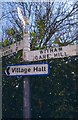
Old Direction Sign - Signpost by Main Road, Trudoxhill
Pyramid finial - 3 arms; Somerset SCC pyramid by the UC road, in parish of Trudoxhill (Mendip District), Main Road in village at junction with Foghamshire Lane, near PH.
Surveyed
Milestone Society National ID: SO_ST7443
Image: © Milestone Society
Taken: Unknown
0.05 miles
5

2010 : Notice board outside The White Hart Inn, Trudoxhill
A brief search of the WWW revealed nothing of the history of the house. Indeed, there is more here, it was established around 1688.
It would appear my search of the WWW was too brief, the following appears in http://www.whiteharttrudoxhill.co.uk/
"The Grade 2 listed building, dating from 1625 has a chequered history including once being the local blacksmiths, a brewery and also a dance hall for the locally based American GI’s. These days the White Hart is now happily trading as a free house with a great reputation for food and fun."
Image: © Maurice Pullin
Taken: 25 Oct 2010
0.05 miles
6
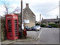
Telephone box, Trudoxhill
K6 style telephone box with the White Hart Inn in the background.
Image: © Maigheach-gheal
Taken: 1 Mar 2009
0.07 miles
7
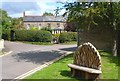
Carved Bench, Trudoxhill
This elaborately carved seat is on a small green near the White Hart pub.
Image: © Des Blenkinsopp
Taken: 22 Aug 2014
0.07 miles
8
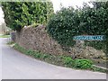
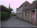
Foghamshire Lane, Trudoxhill
There was no particular reason to take a picture of this lane other than I like the name. It is part of the Macmillan Way.
Image: © Maigheach-gheal
Taken: 1 Mar 2009
0.07 miles
9

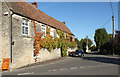
Trudoxhill
A view looking southeast at the centre of the village of Trudoxhill. The White Hart Inn public house is at left.
Image: © Phil Williams
Taken: 12 Mar 2006
0.08 miles
10
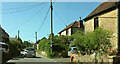
Macmillan Way in Trudoxhill
The LDP follows the main village street north-westwards. This was taken a little further up the road from Image
Image: © Derek Harper
Taken: 27 May 2022
0.13 miles