IMAGES TAKEN NEAR TO
Oakfield Road, FROME, BA11 4JH
Introduction
This page details the photographs taken nearby to Oakfield Road, BA11 4JH by members of the Geograph project.
The Geograph project started in 2005 with the aim of publishing, organising and preserving representative images for every square kilometre of Great Britain, Ireland and the Isle of Man.

There are currently over 7.5m images from over14,400 individuals and you can help contribute to the project by visiting https://www.geograph.org.uk
Image Map
Images are licensed for reuse under creativecommons.org/licenses/by-sa/2.0
Notes
- Clicking on the map will re-center to the selected point.
- The higher the marker number, the further away the image location is from the centre of the postcode.
Image Listing (16 Images Found)
Images are licensed for reuse under creativecommons.org/licenses/by-sa/2.0
Image
Details
Distance
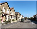
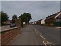
2
2008 : Nunney Road, Frome
The speed limit sign indicates the end of a 20mph zone. If we were really interested in road safety there would be more.
Houses late Victorian/Edwardian?
Image: © Maurice Pullin
Taken: 9 Dec 2008
0.08 miles
3

Oakhill Road
A view looking north along Oakhill Road. Oakhill School is on the left.
Image: © Phil Williams
Taken: 26 Jul 2006
0.11 miles
4
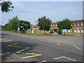
Frome police station
A view looking north across Oakhill Road from Oakhill School towards Frome police station.
Image: © Phil Williams
Taken: 26 Jul 2006
0.11 miles
5

Nunney Road, Frome
Looking back towards the town.
Image: © David Purchase
Taken: 19 Sep 2019
0.11 miles
6
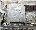
Benchmark on Nunney Road
The Ordnance Survey cut mark can be found on a house wall on Image, for more information visit http://www.bench-marks.org.uk/bm41794
Image: © Jonathan Kington
Taken: 7 Mar 2012
0.12 miles
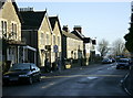
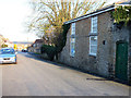
7
Oakfield Academy and former site of police station
The school on the left is now known as Oakfield Academy. "Oakfield has educated the children of Frome and surrounding villages since 1941: Frome’s first co-educational, comprehensive community day school. In 1973 the school changed from being a secondary modern comprehensive to a middle school; which catered for 9-13 year old pupils." http://www.oakfieldacademy.co.uk/our-academy/the-academy/ The former site of the police station Image became housing in 2018 - the bus stop in front is still named after the police station - with Stoodley Terrace named after the late PC Kevin Stoodley. Further along The Old Nurseries (shortlisted for Best High Volume New Housing Development at the South West LABC Building Excellence Awards 2019) recalls the fact that the site was nurseries before the police station was built there.
Image: © HelenK
Taken: 1 Jun 2019
0.13 miles
8
Nunney Road
Looking down Nunney Road towards Frome town centre, there is an Ordnance Survey benchmark on the house on the right (see Image).
Image: © Jonathan Kington
Taken: 7 Mar 2012
0.15 miles
9
Entrances to #28 and #30 Weymouth Road
There is an OS benchmark Image on the right hand side gatepost of the entrance at the left side of the image
Image: © Roger Templeman
Taken: 20 Sep 2013
0.21 miles
10

Benchmark on gatepost at #28 Weymouth Road
Ordnance Survey cut mark benchmark described on the Bench Mark Database at http://www.bench-marks.org.uk/bm51772
Image: © Roger Templeman
Taken: 20 Sep 2013
0.22 miles