IMAGES TAKEN NEAR TO
Walkers Drive, BA11 4FS
Introduction
This page details the photographs taken nearby to Walkers Drive, BA11 4FS by members of the Geograph project.
The Geograph project started in 2005 with the aim of publishing, organising and preserving representative images for every square kilometre of Great Britain, Ireland and the Isle of Man.

There are currently over 7.5m images from over14,400 individuals and you can help contribute to the project by visiting https://www.geograph.org.uk
Image Map
Images are licensed for reuse under creativecommons.org/licenses/by-sa/2.0
Notes
- Clicking on the map will re-center to the selected point.
- The higher the marker number, the further away the image location is from the centre of the postcode.
Image Listing (11 Images Found)
Images are licensed for reuse under creativecommons.org/licenses/by-sa/2.0
Image
Details
Distance
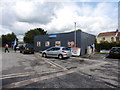
2

The Theobald Arms, Nunney Catch
The Theobald Arms, Nunney Catch, looking even worse for wear than in 2009, see
Image
Image: © Vieve Forward
Taken: 12 Jul 2014
0.11 miles
3
Nunney Catch Cafe
A view looking east across the truck parking area at the Nunney Catch service area on the A350.
Image: © Phil Williams
Taken: 5 Mar 2006
0.11 miles

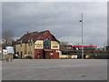
6
The Theobald Arms
At Nunney Catch, this inn was on the main coach road but has been bypassed in recent years and the building itself has seen better days.
Image: © Graham Horn
Taken: 3 May 2007
0.12 miles
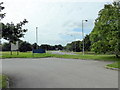
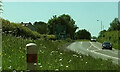
7

Splitter island, Nunney Catch Roundabout
Turning left away from the roundabout is the A361 to Shepton Mallet. I'd have thought there should be a roadsign on the island confirming thus.
Image: © Derek Harper
Taken: 27 May 2022
0.13 miles
8
A361 approaching Nunney Catch
Looking left from Image along Marston Road; the Nunney Catch roundabout can be glimpsed ahead. On the left is Braeside Farm.
Image: © Derek Harper
Taken: 27 May 2022
0.18 miles
9

The entrance to Braeside Farm, Nunney Catch
It also leads to a couple of new houses on the way.
Image: © David Howard
Taken: 5 May 2018
0.18 miles
10

Marston Road, Nunney
At the junction of the road from Trudoxhill with the A361 Marston Road. The brown sign pointing towards the camera advertises "Trudoxhill Macmillan Way" and both OS maps and the LWDA map show the Way crossing the main road at this junction. But I can't see any route for it on the other side of this junction, nor any waymark. Surely it should follow the lane shown in Image which passes safely beneath the main road? However, no waymarking is visible on Streetview where this lane leaves the road from Trudoxhill.
Image: © Derek Harper
Taken: 27 May 2022
0.21 miles