IMAGES TAKEN NEAR TO
Kersey Court, FROME, BA11 3NE
Introduction
This page details the photographs taken nearby to Kersey Court, BA11 3NE by members of the Geograph project.
The Geograph project started in 2005 with the aim of publishing, organising and preserving representative images for every square kilometre of Great Britain, Ireland and the Isle of Man.

There are currently over 7.5m images from over14,400 individuals and you can help contribute to the project by visiting https://www.geograph.org.uk
Image Map (Loading...)


Getting Data...Please wait
Leaflet Map data © OpenStreetMap
Images are licensed for reuse under creativecommons.org/licenses/by-sa/2.0
Notes
- Clicking on the map will re-center to the selected point.
- The higher the marker number, the further away the image location is from the centre of the postcode.
Image Listing (17 Images Found)
Images are licensed for reuse under creativecommons.org/licenses/by-sa/2.0
Image
Details
Distance
1

Mendips Way Panorama 4
Image: © Roger Gittins
Taken: 19 May 2009
0.09 miles
2

Mendips Way Panorama 3
Image: © Roger Gittins
Taken: 19 May 2009
0.12 miles
3
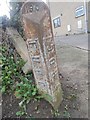
Old Boundary Marker
Municipal Boundary Marker at the side of the drive to a house on the south side of Egford Lane. FROME parish. In raised lettering F.R.D.C. on the left face and F.U.D.C. on the right face, both vertically, with 1901 horizontally on the head face, marking the former boundary of Frome Urban and Frome Rural Districts.
Milestone Society National ID: SO_FUDFRD03pb
Image: © P Hamilton
Taken: 30 Nov 2019
0.13 miles
4
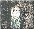
Old Milestone, A362, Vallis Road, Frome
The milestone is located south of Vallis House on the verge in front of the boundary wall, on the west side of the road. Parish of Selwood (Mendip District). Metal plate attached to stone post, Frome shield design, erected by the Frome turnpike trust in the 18th century.
Inscription reads:-
FROME / 1
Grade II Listed, List Entry Number: 1392515 https://historicengland.org.uk/listing/the-list/list-entry/1392515
Milestone Society National ID: SO_FRRS01
Image: © JR Dowding
Taken: 20 Feb 2005
0.14 miles
5

2009 : A362 Vallis Road Frome
Less than a mile from the town centre.
The hill in the distance is Cley Hill near Warminster Image
Image: © Maurice Pullin
Taken: 8 Dec 2009
0.17 miles
6

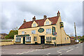
Former Toll House, Cottle's Oak, Frome
The side building at 121, Broadway, at the junction with Egford Road.
Somerset HER.
HER number: 40866 https://www.heritagegateway.org.uk/Gateway/Results_Single.aspx?uid=40866&resourceID=100
Surveyed
Milestone Society National ID: SO.FRO01
Image: © Alan Rosevear
Taken: 1 Dec 2012
0.19 miles
7
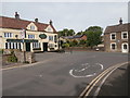
Miss Moneypenny's house
The blue plaque on the house on the right commemorates the fact that from 1994 to 2001 it was the home of Lois Maxwell, who played Miss Moneypenny in many of the earlier James Bond films. The Royal Oak (which perhaps takes its name because it stands on Oakfield Road) has recently been saved from closure and reopened about six weeks before this photograph was taken.
Image: © HelenK
Taken: 1 Jun 2019
0.20 miles
9
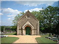
Frome Dissenters Cemetery Chapel
View of Chapel from Vallis Road
Image: © Jim Parsons
Taken: 26 Nov 2007
0.20 miles
10
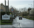
2009 : A362 entering Frome
A small car with "go faster" stripes seems to be keeping to the 30 mph speed limit.
Snow White and the Seven Dwarfs opens at the Frome Memorial Theatre on 29th December. Good to see our Acker (Acker Bilk) is still going strong.
Image: © Maurice Pullin
Taken: 8 Dec 2009
0.21 miles