IMAGES TAKEN NEAR TO
Vallis Road, FROME, BA11 3EN
Introduction
This page details the photographs taken nearby to Vallis Road, BA11 3EN by members of the Geograph project.
The Geograph project started in 2005 with the aim of publishing, organising and preserving representative images for every square kilometre of Great Britain, Ireland and the Isle of Man.

There are currently over 7.5m images from over14,400 individuals and you can help contribute to the project by visiting https://www.geograph.org.uk
Image Map (Loading...)


Getting Data...Please wait
Leaflet Map data © OpenStreetMap
Images are licensed for reuse under creativecommons.org/licenses/by-sa/2.0
Notes
- Clicking on the map will re-center to the selected point.
- The higher the marker number, the further away the image location is from the centre of the postcode.
Image Listing (15 Images Found)
Images are licensed for reuse under creativecommons.org/licenses/by-sa/2.0
Image
Details
Distance
1
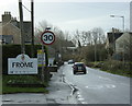
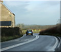
2009 : A362 entering Frome
A small car with "go faster" stripes seems to be keeping to the 30 mph speed limit.
Snow White and the Seven Dwarfs opens at the Frome Memorial Theatre on 29th December. Good to see our Acker (Acker Bilk) is still going strong.
Image: © Maurice Pullin
Taken: 8 Dec 2009
0.02 miles
2
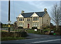
2009 : Vallis House on the A362
At the north western edge of Frome.
The sign on the post advertises holiday cottages.
The sign on the gate suggests caution as there may be free range children and animals.
Image: © Maurice Pullin
Taken: 8 Dec 2009
0.07 miles
3
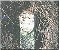
Old Milestone, A362, Vallis Road, Frome
The milestone is located south of Vallis House on the verge in front of the boundary wall, on the west side of the road. Parish of Selwood (Mendip District). Metal plate attached to stone post, Frome shield design, erected by the Frome turnpike trust in the 18th century.
Inscription reads:-
FROME / 1
Grade II Listed, List Entry Number: 1392515 https://historicengland.org.uk/listing/the-list/list-entry/1392515
Milestone Society National ID: SO_FRRS01
Image: © JR Dowding
Taken: 20 Feb 2005
0.08 miles
4
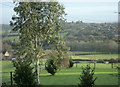
2009 : East from the A362 near Vallis House
Looking into the valley of the River Frome as it heads north out of Frome. The river and its attendant sewage works are hidden among the trees.
The northern suburbs of the town are on the far side of the valley.
Image: © Maurice Pullin
Taken: 8 Dec 2009
0.09 miles
5
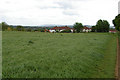
2009 : A362 leaving Frome on Vallis Road
Next Buckland Dinham then on to Radstock.
Image: © Maurice Pullin
Taken: 8 Dec 2009
0.10 miles
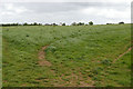
6
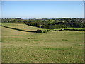
Outskirts of Frome
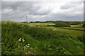
From the East Mendips Way approaching Frome. In the far distance on the escarpment is Westbury White Horse; see square Image
Image: © Roger Gittins
Taken: 19 May 2009
0.12 miles
8
Mendips Way Panorama 2
Image: © Roger Gittins
Taken: 19 May 2009
0.14 miles
9

Mendips Way Panorama 3
Image: © Roger Gittins
Taken: 19 May 2009
0.16 miles