IMAGES TAKEN NEAR TO
Whatcombe Road, FROME, BA11 3AF
Introduction
This page details the photographs taken nearby to Whatcombe Road, BA11 3AF by members of the Geograph project.
The Geograph project started in 2005 with the aim of publishing, organising and preserving representative images for every square kilometre of Great Britain, Ireland and the Isle of Man.

There are currently over 7.5m images from over14,400 individuals and you can help contribute to the project by visiting https://www.geograph.org.uk
Image Map
Images are licensed for reuse under creativecommons.org/licenses/by-sa/2.0
Notes
- Clicking on the map will re-center to the selected point.
- The higher the marker number, the further away the image location is from the centre of the postcode.
Image Listing (33 Images Found)
Images are licensed for reuse under creativecommons.org/licenses/by-sa/2.0
Image
Details
Distance
1
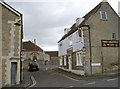
The Griffin
A pub at the top of Welshmill Lane and just up from Milk Street - home of the famous Frome brewery that runs it.
Image: © Neil Owen
Taken: 13 May 2014
0.13 miles
2
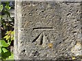
Benchmark on North End House, Bridge Street, Frome
Ordnance Survey benchmark on right hand gatepost of driveway, described on database at http://www.bench-marks.org.uk/bm57380.
Image: © Becky Williamson
Taken: 8 Jun 2015
0.14 miles
3
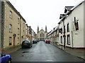
Trinity Street
The Holy Trinity Church keeps a watchful eye on Trinity Street. The church was built in 1857, Architect: E E Goodridge, and is Grade II* listed. The street, however, is the main street of the late 17C Trinity suburb. Either the suburb was renamed in the 19C or there was an earlier church here.
Image: © Humphrey Bolton
Taken: 19 Sep 2013
0.15 miles
4
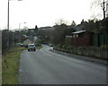
2009 : Whatcombe Road Frome
Looking toward the town centre.
Image: © Maurice Pullin
Taken: 8 Dec 2009
0.16 miles
5
View to Frome
View from the bank of the River From to housing on Whatcombe Road, Frome.
Image: © Roger Gittins
Taken: 18 May 2009
0.18 miles
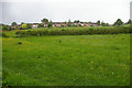
6

Two into one
This section of Welshmill Lane divides into two for a short run, just before it returns to a single carriageway. However, just after that it becomes a single track as it passes under the railway bridge - all without the aid of traffic lights! See Image] for another view.
Image: © Neil Owen
Taken: 13 May 2014
0.18 miles
7
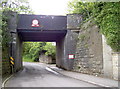
Welshmill Lane railway bridge
Part of the G.W.R. (Radstock branch) railway line into Frome. There is a benchmark on the stone block walling to the right - see Image Interestingly, the single road section underneath it is not light-controlled. Also see Image] for a closer look at the signs above.
Image: © Neil Owen
Taken: 13 May 2014
0.19 miles
8
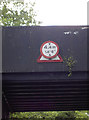
A change of emphasis
The sign above the Welshmill Lane railway bridge overlays an earlier one - and a triangular one at that. The Highway Code lists triangular signs as being warnings (mostly) whereas the circular give orders. See Image] for another view.
Image: © Neil Owen
Taken: 13 May 2014
0.19 miles
9
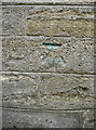
Green for a change
It's not unknown for old benchmarks to be resurveyed and a touch of yellow paint applied to aid the location, but not green. Perhaps it was made by someone other than a surveyor. See http://www.bench-marks.org.uk/bm57383 for the entry in the Benchmark Database and Image] for a wider view.
Image: © Neil Owen
Taken: 13 May 2014
0.19 miles
10
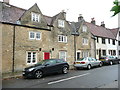
17C houses. Trinity Street
A row of houses built c>1680, listed Grade II. The listing details state that No.1 was the King's Head Inn.
Image: © Humphrey Bolton
Taken: 19 Sep 2013
0.19 miles