IMAGES TAKEN NEAR TO
Buckland Dinham, FROME, BA11 2RD
Introduction
This page details the photographs taken nearby to BA11 2RD by members of the Geograph project.
The Geograph project started in 2005 with the aim of publishing, organising and preserving representative images for every square kilometre of Great Britain, Ireland and the Isle of Man.

There are currently over 7.5m images from over14,400 individuals and you can help contribute to the project by visiting https://www.geograph.org.uk
Image Map (Loading...)


Getting Data...Please wait
Leaflet Map data © OpenStreetMap
Images are licensed for reuse under creativecommons.org/licenses/by-sa/2.0
Notes
- Clicking on the map will re-center to the selected point.
- The higher the marker number, the further away the image location is from the centre of the postcode.
Image Listing (3 Images Found)
Images are licensed for reuse under creativecommons.org/licenses/by-sa/2.0
Image
Details
Distance
1
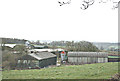
2008 : Lydes Farm near Buckland Dinham
On the A362 west of Buckland Dinham, Lydes Farm is seen here from Colliery Lane, a side road leading to Mells.
Image: © Maurice Pullin
Taken: 31 Mar 2008
0.05 miles
2
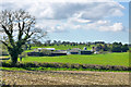
Lydes Farm
Looking from Collier's Lane.
Image: © Robin Webster
Taken: 2 Apr 2017
0.05 miles
3
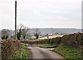
2008 : Collier's Lane looking east toward Buckland Dinham
The lane going to the right at the junction goes to Hill House Farm.
We have a distant view of New Close Farm on the A362.
Image: © Maurice Pullin
Taken: 31 Mar 2008
0.25 miles