IMAGES TAKEN NEAR TO
Iron Mill Lane, FROME, BA11 2NR
Introduction
This page details the photographs taken nearby to Iron Mill Lane, BA11 2NR by members of the Geograph project.
The Geograph project started in 2005 with the aim of publishing, organising and preserving representative images for every square kilometre of Great Britain, Ireland and the Isle of Man.

There are currently over 7.5m images from over14,400 individuals and you can help contribute to the project by visiting https://www.geograph.org.uk
Image Map
Images are licensed for reuse under creativecommons.org/licenses/by-sa/2.0
Notes
- Clicking on the map will re-center to the selected point.
- The higher the marker number, the further away the image location is from the centre of the postcode.
Image Listing (11 Images Found)
Images are licensed for reuse under creativecommons.org/licenses/by-sa/2.0
Image
Details
Distance
1
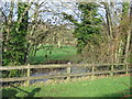
Mells River
A view looking north from Iron Mill Lane to the Mells River at White Mill Farm
Image: © Phil Williams
Taken: 3 Dec 2006
0.01 miles
2
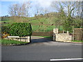
Entrance to Whitemill Farm
A view looking north across Iron Mill Lane towards the entrance to Whitemill Farm.
Image: © Phil Williams
Taken: 3 Dec 2006
0.01 miles
4
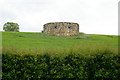
Pillbox
From http://www.pillbox-study-group.org.uk/ukfcdatabasefpage.htm this pillbox appears to be one of half a dozen WW2 defences along Iron Mill Lane and Whitechapel Lane. It is not known whether the others survive, none seem to be shown on Google Earth.
Image: © Roger Gittins
Taken: 16 May 2009
0.06 miles
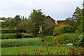
5

Spring Gardens
The confluence of the Mells River and the River Frome is in the trees at the right hand edge of the picture
Image: © David Doff
Taken: 1 Oct 2008
0.14 miles
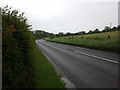
6
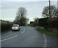
2009 : Iron Mill Lane
Looking north from the junction with Cuckoo Lane.
Meets the B3090 at Oldford.
Image: © Maurice Pullin
Taken: 8 Dec 2009
0.19 miles
7
Iron Mill
Based on location, mill lead and sluices plus OS map information, it is assumed that these buildings are Iron Mill and Iron Mill Cottage.
Image: © Roger Gittins
Taken: 16 May 2009
0.19 miles
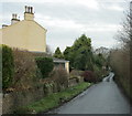
8
Longhouse Farm
This is the entrance to Iron Mill, Mill Cottage and Longhouse Farm.
It is assumed that the large house to the left is Longhouse Farm as the mill is out of shot to the right Image
Image: © Roger Gittins
Taken: 16 May 2009
0.21 miles
9
2009 : Cuckoo Lane heading east
Seen from the junction with Iron Mill Lane. The B3090 is about half a mile ahead.
Image: © Maurice Pullin
Taken: 8 Dec 2009
0.24 miles
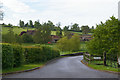
10
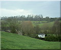
2009 : North west from Iron Mill Lane
Opposite the junction with Cuckoo Lane.
The Mells River is at the bottom of the valley, at one time it powered a number of iron mills in this area.
"In the late 18th and early 19th centuries, the Fussell family ran a highly successful iron works business producing edge tools such as scythes, sickles, spades, shovels and other agricultural implements."
The above was copied from: http://www.bgs.ac.uk/mendips/Industrial_archaeology/fussells.html
Image: © Maurice Pullin
Taken: 8 Dec 2009
0.24 miles