IMAGES TAKEN NEAR TO
Woodland Way, FROME, BA11 2FL
Introduction
This page details the photographs taken nearby to Woodland Way, BA11 2FL by members of the Geograph project.
The Geograph project started in 2005 with the aim of publishing, organising and preserving representative images for every square kilometre of Great Britain, Ireland and the Isle of Man.

There are currently over 7.5m images from over14,400 individuals and you can help contribute to the project by visiting https://www.geograph.org.uk
Image Map (Loading...)


Getting Data...Please wait
Leaflet Map data © OpenStreetMap
Images are licensed for reuse under creativecommons.org/licenses/by-sa/2.0
Notes
- Clicking on the map will re-center to the selected point.
- The higher the marker number, the further away the image location is from the centre of the postcode.
Image Listing (15 Images Found)
Images are licensed for reuse under creativecommons.org/licenses/by-sa/2.0
Image
Details
Distance
1
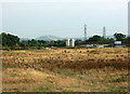
2008 : Undeveloped development site, Frome
Waiting for the next boom.
As a consolation I offer a distant view of Cley Hill Image
Image: © Maurice Pullin
Taken: 18 Sep 2008
0.04 miles
2

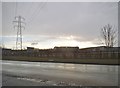
Edge of Frome
At one time none of the town was east of the River From but now nearly half of it is. This is the back of one of the large housing estates on the north eastern edge of the town, viewed from a Yeovil to Bristol train.
Image: © Nigel Mykura
Taken: 6 Apr 2011
0.15 miles
4
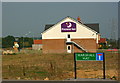
2008 : Frome Flyer, Premier Inn
On Marshall Way.
Searched the internet but could find nothing interesting about it, there probably isn't.
26.9.2008: It appears I have done this establishment an injustice. Alan Longbottom tells me the Frome Flyer was none other than the racing driver Jenson Button, it is on the internet and I missed it. Not so uninteresting after all.
Image: © Maurice Pullin
Taken: 18 Sep 2008
0.16 miles

6

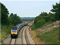
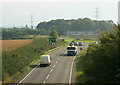
A361, Frome Bypass
Looking northwest along the A361 towards a new roundabout installed to provide access to a business park development adjacent to the bypass.
Image: © Phil Williams
Taken: 29 Nov 2005
0.17 miles
7
2008 : Coalway Lane Bridge, Frome
A First Great Western HST has just passed under Coalway Lane Bridge and is heading north east toward Westbury.
Image: © Maurice Pullin
Taken: 18 Sep 2008
0.20 miles
8
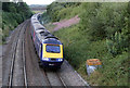
Nearing Journey's End
Class 43, 43132, leads a First Great Western HST set towards Clink Road Junction at Coalway Lane. The bridge in the distance carries the A361 over the railway. The pink flowers of the Rosebay Willowherb are still going strong in this late summer view.
This train is the (1J93) 18:06 service from Paddington which will terminate at Frome at 20:06.
Image: © Martin Addison
Taken: 20 Aug 2013
0.20 miles
9
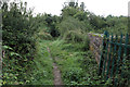
Coalway Lane Bridge
Now just a footpath rather than a lane, pedestrians are more likely to meet cyclists that horse-drawn carts! This is the bridge over the West of England mainline close to Clink Road Junction on the outskirts of Frome. Autumn is fast approaching and there is dew on the grass. The Blackberries have formed but have still to ripen.
Image: © Martin Addison
Taken: 21 Aug 2013
0.21 miles
10
2008 : Frome bypass looking south
From Berkley Lane overbridge.
The roundabout is at the entrance to the new business park.
Image: © Maurice Pullin
Taken: 18 Sep 2008
0.22 miles