IMAGES TAKEN NEAR TO
Bartlett Close, FROME, BA11 2EZ
Introduction
This page details the photographs taken nearby to Bartlett Close, BA11 2EZ by members of the Geograph project.
The Geograph project started in 2005 with the aim of publishing, organising and preserving representative images for every square kilometre of Great Britain, Ireland and the Isle of Man.

There are currently over 7.5m images from over14,400 individuals and you can help contribute to the project by visiting https://www.geograph.org.uk
Image Map
Images are licensed for reuse under creativecommons.org/licenses/by-sa/2.0
Notes
- Clicking on the map will re-center to the selected point.
- The higher the marker number, the further away the image location is from the centre of the postcode.
Image Listing (13 Images Found)
Images are licensed for reuse under creativecommons.org/licenses/by-sa/2.0
Image
Details
Distance


5
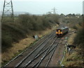
2009 : Looking south from Clink Road railway bridge
The main line between Paddington and the south west heads into the distance, next station, Bruton.
The local train is showing its rear (red) lights so it is going onto the loop line through Frome Station. The points behind it are set to switch it from the down (left) line to the up line then into the loop.
Image: © Maurice Pullin
Taken: 8 Dec 2009
0.17 miles
7

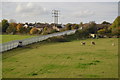
2009 : A361 Frome bypass looking south from Clink Road
The bridge in the distance carries the A3098.
An interesting comparison with Image] taken nearly 3 years previously with a wider angle lens.
Image: © Maurice Pullin
Taken: 8 Dec 2009
0.20 miles
8
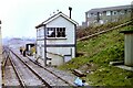
Clink Road Junction and Signal Box, 1984
Taken from a train crossing over to take the line to Frome, diverging right. The 'box is long since gone as the junction is controlled remotely, but the sloping path and handrail on the right can still be seen.
Interestingly, the 114½ milepost seen outside the 'box is not measured by the direct route from London, but the original route via Swindon and Melksham. The actual mileage from London via the later, more direct route via Newbury, is about 15 miles shorter.
Image: © Nigel Thompson
Taken: 15 Mar 1984
0.21 miles
9
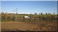
A361 near Frome
A stretch of A road running parallel to the main railway line between Taunton and Westbury as it avoids the loop into Frome station. The small rectangular field in between, shown as pasture on satellite images, has been dug up for something or other.
Image: © Derek Harper
Taken: 19 Mar 2012
0.22 miles