IMAGES TAKEN NEAR TO
Holmbury Close, FROME, BA11 2ER
Introduction
This page details the photographs taken nearby to Holmbury Close, BA11 2ER by members of the Geograph project.
The Geograph project started in 2005 with the aim of publishing, organising and preserving representative images for every square kilometre of Great Britain, Ireland and the Isle of Man.

There are currently over 7.5m images from over14,400 individuals and you can help contribute to the project by visiting https://www.geograph.org.uk
Image Map (Loading...)


Getting Data...Please wait
Leaflet Map data © OpenStreetMap
Images are licensed for reuse under creativecommons.org/licenses/by-sa/2.0
Notes
- Clicking on the map will re-center to the selected point.
- The higher the marker number, the further away the image location is from the centre of the postcode.
Image Listing (20 Images Found)
Images are licensed for reuse under creativecommons.org/licenses/by-sa/2.0
Image
Details
Distance
1
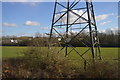
Holmbury Close
Power lines, garages and 1980s houses in Frome.
Image: © Burgess Von Thunen
Taken: 1 Mar 2012
0.01 miles
2
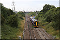
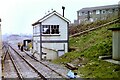
Clink Road Junction
The West of England mainline with the Frome line diverging on the right. The netting suspended across the railway line at this point is temporary - there was maintenance work being carried out on the national grid network of pylons in the area.
The train in the foreground has just come off the Frome branch and is the 2D03 service from Weymouth to Bristol Parkway - departing Weymouth at 05:33 and due at Parkway at 08:29. It called at Frome at 07:04 with next stop Westbury.
Image: © Martin Addison
Taken: 21 Aug 2013
0.05 miles
3

A361 Frome bypass
A view looking southwest along the A361 Frome bypass from the Clink overbridge.
Image: © Phil Williams
Taken: 17 Jan 2006
0.05 miles
4
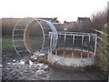
Feed rings at the Clink
A pair of feed rings in a paddock adjacent to the Clink, Frome.
Image: © Phil Williams
Taken: 17 Jan 2006
0.05 miles
5
Clink Road Junction and Signal Box, 1984
Taken from a train crossing over to take the line to Frome, diverging right. The 'box is long since gone as the junction is controlled remotely, but the sloping path and handrail on the right can still be seen.
Interestingly, the 114½ milepost seen outside the 'box is not measured by the direct route from London, but the original route via Swindon and Melksham. The actual mileage from London via the later, more direct route via Newbury, is about 15 miles shorter.
Image: © Nigel Thompson
Taken: 15 Mar 1984
0.07 miles
6

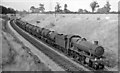
Bristol - Weymouth express approaching Clink Road Junction, Frome
View NE, towards Westbury (and Bristol, via Bath), Newbury, Reading and London, etc.; ex-GWR Paddington - Reading - Westbury - Taunton - Exeter - Plymouth - Penzance, also Wilts., Somerset and Weymouth (Swindon/Bath - Westbury - Yeovil - Weymouth, main lines. (At Clink Road the Frome cut-off line ran to Blacksbridge Junction). The 09.43 Bristol Temple Meads to Weymouth is headed by 4-6-0 No. 5924 'Dinton Hall' (built 5/33, withdrawn 12/63) and will call in at Frome. (See also Image]).
Image: © Ben Brooksbank
Taken: 22 Aug 1959
0.09 miles
7
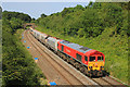
Clink Road
Freight train at Clink Road.
Image: © Wayland Smith
Taken: 28 Jun 2019
0.10 miles
8
Down Milk empties at Clink Road, near Frome
View NE, towards Westbury, Reading and London; ex-GWR London - Reading - Westbury - Taunton etc. main line. (Just ahead of the train the Frome-avoiding line to Blatchbridge Junction commences). This is probably the very important Kensington - Plymouth Milk empties, returning tank-wagons to various Milk Depots in the West Country which supplied a large proportion of the capital's needs - before the age of Motorways. The locomotive is 4-6-0 No. 4941 'Llangedwyn Hall' (built 7/29, withdrawn 10/62).
Image: © Ben Brooksbank
Taken: 22 Aug 1959
0.10 miles
9
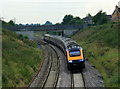
2008 : From Coalway Lane bridge, Frome
A First Great Western HST approaching Coalway Lane bridge, near Frome.
The junction visible beyond the next bridge is the northern end of the loop through Frome station which the HST has bypassed.
Image: © Maurice Pullin
Taken: 18 Sep 2008
0.11 miles