IMAGES TAKEN NEAR TO
Wyke Champflower, BRUTON, BA10 0PN
Introduction
This page details the photographs taken nearby to BA10 0PN by members of the Geograph project.
The Geograph project started in 2005 with the aim of publishing, organising and preserving representative images for every square kilometre of Great Britain, Ireland and the Isle of Man.

There are currently over 7.5m images from over14,400 individuals and you can help contribute to the project by visiting https://www.geograph.org.uk
Image Map (Loading...)


Getting Data...Please wait
Leaflet Map data © OpenStreetMap
Images are licensed for reuse under creativecommons.org/licenses/by-sa/2.0
Notes
- Clicking on the map will re-center to the selected point.
- The higher the marker number, the further away the image location is from the centre of the postcode.
Image Listing (23 Images Found)
Images are licensed for reuse under creativecommons.org/licenses/by-sa/2.0
Image
Details
Distance
1
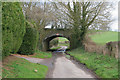
Former Railway Bridge near Cole
Former Somerset & Dorset bridge near Wyke House.
Image: © Wayland Smith
Taken: 17 Mar 2008
0.02 miles
2
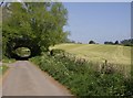
Former railway bridge
This bridge once carried the Somerset and Dorset railway over Wyke Lane at Wyke Champflower. The bridge still remains, and is maintained, but the railway, which would have run along a low embankment on the right, has long since disappeared.
Image: © Graham Horn
Taken: 4 May 2007
0.03 miles
3
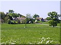
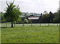
Wyke Champflower manor and church
From the minor road out of the village to the south.
Image: © Graham Horn
Taken: 4 May 2007
0.10 miles
4
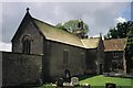
Wyke Champflower: church of the Holy Trinity
...in yet another little village with an idyllic name – Holy Trinity, Wyke Champflower.
Image: © Chris Downer
Taken: 3 Jun 1999
0.10 miles
5
Wyke Champflower church
A small 17th century church attached to the manor.
Image: © Graham Horn
Taken: 4 May 2007
0.11 miles
6

Church of the Holy Trinity, Wyke Champflower
Listed Grade I. A Jacobean (1623) church attached to the manor house, replacing an earlier chapel https://seearoundbritain.com/venues/holy-trinity-church-wyke-champflower-limited-opening-free-entry. The plaque near the end of the manor house wall commemorates Sir Duncan George Mackenzie, a former resident.
Image: © Tim Heaton
Taken: 2 Feb 2022
0.12 miles
7
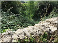
Wall of former Railway Bridge
Here in Wyke lane is the southern side of the bridge wall, looking down on to what was the old Track bed of the Somerset and Dorset joint railway as you can see it completely overgrown and it as if it's never been any different
Image: © Ant Basterfield
Taken: 10 Aug 2016
0.15 miles
8
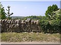
Former railway bridge
This is the parapet of one of the bridges over the former Somerset and Dorset railway. The line used to be in a cutting heading towards the trees but the land has been infilled as can be seen by a car parked at road level and the tennis courts beyond.
Image: © Graham Horn
Taken: 4 May 2007
0.16 miles
9
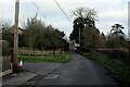
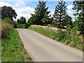
Wyke Road
Heading north east towards Wyke Champflower
Image: © Chris Heaton
Taken: 2 Feb 2022
0.16 miles
10
Former Somerset and Dorset railway bridge
Here at Wyke Campflower west of Bruton is the road under which the former S and D Railway used to run. On the right hand side of the Bridge all of the former cutting has been infilled as is seen be the healthy growth of trees whereas on the left what's left of the trackbed is overgrown and part filled with water.
Image: © Ant Basterfield
Taken: 10 Aug 2016
0.17 miles