IMAGES TAKEN NEAR TO
Silver Street, BRUTON, BA10 0EB
Introduction
This page details the photographs taken nearby to Silver Street, BA10 0EB by members of the Geograph project.
The Geograph project started in 2005 with the aim of publishing, organising and preserving representative images for every square kilometre of Great Britain, Ireland and the Isle of Man.

There are currently over 7.5m images from over14,400 individuals and you can help contribute to the project by visiting https://www.geograph.org.uk
Image Map
Images are licensed for reuse under creativecommons.org/licenses/by-sa/2.0
Notes
- Clicking on the map will re-center to the selected point.
- The higher the marker number, the further away the image location is from the centre of the postcode.
Image Listing (234 Images Found)
Images are licensed for reuse under creativecommons.org/licenses/by-sa/2.0
Image
Details
Distance
1
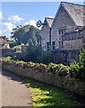
Buildings above the River Brue, Bruton
Viewed from Lower Backway.
Image: © Jaggery
Taken: 17 Sep 2022
0.01 miles
2
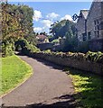
Bend in a path, Lower Backway, Bruton
On a bank of the River Brue. Ahead for Patwell Street.
Image: © Jaggery
Taken: 17 Sep 2022
0.01 miles
3
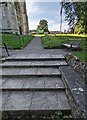
Churchyard entrance steps, Bruton
Ascending into St Mary's churchyard in
the Church of England Diocese of Bath & Wells.
Image: © Jaggery
Taken: 17 Sep 2022
0.01 miles
4
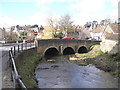
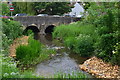
Old bridge over the River Brue, Bruton
Image: © Martin Southwood
Taken: 28 Feb 2006
0.01 miles
5
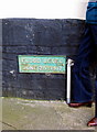
Flood level Patwell Street Bruton
In 1917 242.8 mm of rain fell on Bruton in 24 hours.
Image: © Sarah Smith
Taken: 16 Feb 2009
0.02 miles
6
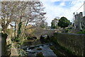
Church Bridge, Bruton
Spanning the River Brue (Celtic river name meaning 'brisk' https://www.oxfordreference.com/view/10.1093/acref/9780199609086.001.0001/acref-9780199609086-e-2391?rskey=qEu9I3&result=2401 ). Listed Grade II "Probably early C19." https://historicengland.org.uk/listing/the-list/list-entry/1056429?section=official-list-entry
Image: © Tim Heaton
Taken: 2 Feb 2022
0.02 miles
7
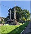
Bruton War Memorial, Somerset
In the NW corner of St Mary's churchyard.
Bruton War Memorial was Grade II Listed in 2014.
Image: © Jaggery
Taken: 17 Sep 2022
0.02 miles
8
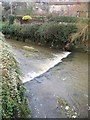
River Brue, Bruton
The River Brue originates in the parish of Brewham, close to the border with Wiltshire in the northeast of Somerset, and on the westernmost edge of the high land of Cranborne Chase and the West Wiltshire Downs.
Image: © Maigheach-gheal
Taken: 22 Jan 2008
0.02 miles
10
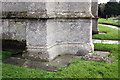
Flood level marker beside St Mary's Church tower
The flood level plate to the right of the tower buttresses records a flood on 28 June 1917. There is also an OS benchmark Image to the left of the buttresses.
Image: © Roger Templeman
Taken: 24 Sep 2012
0.02 miles