IMAGES TAKEN NEAR TO
Eden Road, SOLIHULL, B92 9DT
Introduction
This page details the photographs taken nearby to Eden Road, B92 9DT by members of the Geograph project.
The Geograph project started in 2005 with the aim of publishing, organising and preserving representative images for every square kilometre of Great Britain, Ireland and the Isle of Man.

There are currently over 7.5m images from over14,400 individuals and you can help contribute to the project by visiting https://www.geograph.org.uk
Image Map
Images are licensed for reuse under creativecommons.org/licenses/by-sa/2.0
Notes
- Clicking on the map will re-center to the selected point.
- The higher the marker number, the further away the image location is from the centre of the postcode.
Image Listing (7 Images Found)
Images are licensed for reuse under creativecommons.org/licenses/by-sa/2.0
Image
Details
Distance
1
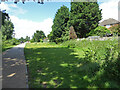
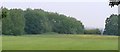
Path in Elmdon Park
At this point the path is heading towards the A45 and is behind houses on the right. The Park was the grounds of a now demolished hall built as a country retreat by a Birmingham ironmaster.
Image: © Chris Allen
Taken: 26 Jun 2021
0.03 miles
2
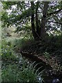
Hatchford Brook, Elmdon Park, Solihull
On the restoration of this stream, a tributary of the River Cole, see Image
Image: © A J Paxton
Taken: 31 Aug 2024
0.05 miles
3
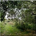
Green corridor, Elmdon Park
This corridor connects the park with Coventry Road and runs alongside the restored Hatchford Brook Image
Image: © A J Paxton
Taken: 31 Aug 2024
0.05 miles
4
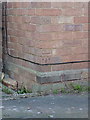
OS benchmark - Elmdon, 52 Fallowfield Road
An OS cutmark on the south-facing wall of 52 Fallowfield Road; originally levelled at 99.19m above Ordnance Datum Newlyn.
Image: © Richard Law
Taken: 16 Feb 2016
0.09 miles
6
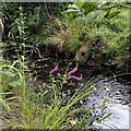
Hatchford Brook restoration, Elmdon Park
The Hatchford Brook flows northwards through Elmdon Park and a green corridor between the suburbs towards Coventry Road, Birmingham Airport and, eventually, the River Cole. An information board explains how it the brook has been 're-naturalised'. The straight, steep-sided concrete channel (see Image] for a nearby example) has been replaced by a more meandering course with shallower sides, backwater channels, pools and riffles (shallower areas with pebbles), all of which should provide a better environment for fish and invertebrates. This work was part-funded by the EU European Regional Development Fund. The flowers seen here are purple loosestrife.
Image: © A J Paxton
Taken: 31 Aug 2024
0.15 miles
7
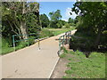
Elmdon Park - bridge over stream
The park is in the grounds of the now demolished Elmdon Hall and owned/operated by Solihull Council. This is one of the major accessible routes through the park.
Image: © Chris Allen
Taken: 26 Jun 2021
0.20 miles