IMAGES TAKEN NEAR TO
Rodney Road, SOLIHULL, B92 8RY
Introduction
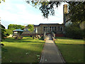
This page details the photographs taken nearby to Rodney Road, B92 8RY by members of the Geograph project.
The Geograph project started in 2005 with the aim of publishing, organising and preserving representative images for every square kilometre of Great Britain, Ireland and the Isle of Man.

There are currently over 7.5m images from over14,400 individuals and you can help contribute to the project by visiting https://www.geograph.org.uk
Image Map
Images are licensed for reuse under creativecommons.org/licenses/by-sa/2.0
Notes
- Clicking on the map will re-center to the selected point.
- The higher the marker number, the further away the image location is from the centre of the postcode.
Image Listing (41 Images Found)
Images are licensed for reuse under creativecommons.org/licenses/by-sa/2.0
Image
Details
Distance
1
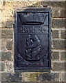
Warwickshire emblems, Ulverley School gates, Rodney Road, Olton
Solihull Borough was part of the now defunct West Midlands County. This tablet shows that the school was built when Solihull was part of Warwickshire. The best known of the elements are the bear and ragged staff (the modern version omits the chain) and the motto NON SANZ DROICT: not without right.
Image: © Robin Stott
Taken: 14 Aug 2014
0.02 miles
2
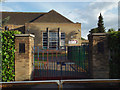
Pedestrian gates, Ulverley School, Rodney Road, Olton
Image: © Robin Stott
Taken: 14 Aug 2014
0.02 miles
3
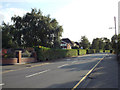
Neat hedges, Rodney Road, Olton
In the centre, beyond the house, are the roofs of Ulverley School.
Image: © Robin Stott
Taken: 14 Aug 2014
0.04 miles
4
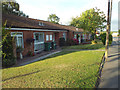
Senior citizens? bungalows, Rodney Road, Olton
Image: © Robin Stott
Taken: 14 Aug 2014
0.05 miles
5
Northeast side of Ulverley School, Rodney Road, Olton
Image: © Robin Stott
Taken: 14 Aug 2014
0.05 miles
6
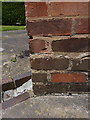
OS benchmark - Ulverley Green, 46 Highwood Avenue
The remains of a rather badly battered & abused OS cutmark on the side wall of no 46 Highwood Avenue, which was originally levelled at 121.69m above Ordnance Datum Newlyn.
Image: © Richard Law
Taken: 23 Jun 2015
0.10 miles
8
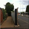
Public footpath, Lode Lane, Solihull
The path runs from Lode Lane to Tanhouse Farm Road and Elmdon Park. It skirts the fenced-off northern side of the Jaguar Land Rover site, one entrance to which can be seen to the right of the fence post. Fenced-off suburban gardens hem the path in on the other side, too. The OS Six Inch 1888-1913 map shows a path running from Lode Lane to the school in Elmdon Park near Elmdon Hall https://maps.nls.uk/geo/explore/side-by-side/#zoom=16&lat=52.44531&lon=-1.76364&layers=6&right=osm . The first section of the modern path follows this one, but it then turns to the left and follows long-lost field boundaries.
Image: © A J Paxton
Taken: 29 Aug 2022
0.14 miles
9
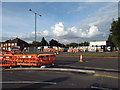
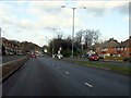
Lode Lane at the Land Rover works north gate, Olton
Access to the site is being remodelled. There is a huge staff car park to the north of the works.
Image: © Robin Stott
Taken: 14 Aug 2014
0.15 miles
10
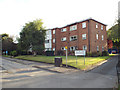
Lode Mill Court flats, Lode Lane, Olton
Shows a distinct stylistic similarity to my own house so I guess it dates from the 1960s.
Image: © Robin Stott
Taken: 14 Aug 2014
0.15 miles