IMAGES TAKEN NEAR TO
Dove House Lane, SOLIHULL, B91 2EE
Introduction
This page details the photographs taken nearby to Dove House Lane, B91 2EE by members of the Geograph project.
The Geograph project started in 2005 with the aim of publishing, organising and preserving representative images for every square kilometre of Great Britain, Ireland and the Isle of Man.

There are currently over 7.5m images from over14,400 individuals and you can help contribute to the project by visiting https://www.geograph.org.uk
Image Map
Images are licensed for reuse under creativecommons.org/licenses/by-sa/2.0
Notes
- Clicking on the map will re-center to the selected point.
- The higher the marker number, the further away the image location is from the centre of the postcode.
Image Listing (10 Images Found)
Images are licensed for reuse under creativecommons.org/licenses/by-sa/2.0
Image
Details
Distance
1
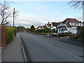
Dovehouse Lane at the junction with Ulverley Green Road
Extensive housing developments (1950s or 60s, by the look of them) to the northwest of Solihull town.
Image: © Richard Law
Taken: 27 Jan 2015
0.09 miles
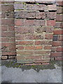
2
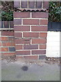
OS benchmark - Ulverley Green Road, no 233
An OS cutmark on the wall of a house on Ulverley Green Road; originally levelled at 123.258m above Ordnance Datum Newlyn.
Image: © Richard Law
Taken: 27 Jan 2015
0.12 miles
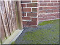
3
OS benchmark - Ulverley Green, near Dove House Farm
An OS cutmark on the wall outside the former Dove House farmhouse (which is now a private house); originally levelled at 130.314m above Ordnance Datum Newlyn.
Image: © Richard Law
Taken: 27 Jan 2015
0.13 miles
4
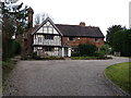
Dove House Farm
The original building in the area, which can presumably say, with some justification "I remember when all this were fields around here". It holds a Grade II* listed status as described at http://www.britishlistedbuildings.co.uk/en-218246-dovehouse-farmhouse- and dates from around 1500.
Image: © Richard Law
Taken: 27 Jan 2015
0.13 miles
5
OS benchmark - Ulverley Green, 91 Dove House Lane
An OS cutmark on a wall pillar at the frontage of 91 Dove House Lane; originally levelled at 127.224m above Ordnance Datum Newlyn.
Image: © Richard Law
Taken: 27 Jan 2015
0.13 miles
6
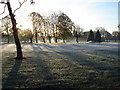
Frosty morning over Olton Golf Course, Solihull
Frosty early morning view across the 10th Fairway at Olton Golf Club, Solihull
Image: © peter lloyd
Taken: 18 Nov 2005
0.16 miles
7
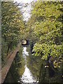
Grand Union Canal as it passes under Dove House Lane Solihull
The bridge in the distance is on Lode Lane Solihull, immediately adjacent to the Land Rover motor works
Image: © peter lloyd
Taken: 4 Dec 2005
0.16 miles
8
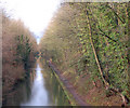
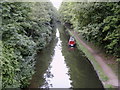
Grand Union Canal near Solihull
Looking north-west towards Birmingham along the Grand Union Canal from Dove House Lane bridge (bridge number 82).
Image: © Andy F
Taken: Unknown
0.23 miles
9
Grand Union Canal
Photo taken from the old bridge across Dove House Lane.
Image: © Carl Baker
Taken: 4 Sep 2006
0.24 miles
10
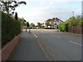
Bourton Road crosses Westbourne Road
Deep in the post-war housing estates of SE Birmingham, where a minor road crosses the main street at a give-way junction.
Image: © Richard Law
Taken: 7 Sep 2016
0.24 miles