IMAGES TAKEN NEAR TO
Broad Oaks Road, SOLIHULL, B91 1HZ
Introduction
This page details the photographs taken nearby to Broad Oaks Road, B91 1HZ by members of the Geograph project.
The Geograph project started in 2005 with the aim of publishing, organising and preserving representative images for every square kilometre of Great Britain, Ireland and the Isle of Man.

There are currently over 7.5m images from over14,400 individuals and you can help contribute to the project by visiting https://www.geograph.org.uk
Image Map (17 Images)


Leaflet Map data © OpenStreetMap
Images are licensed for reuse under creativecommons.org/licenses/by-sa/2.0
Notes
- Clicking on the map will re-center to the selected point.
- The higher the marker number, the further away the image location is from the centre of the postcode.
Image Listing (17 Images Found)
Images are licensed for reuse under creativecommons.org/licenses/by-sa/2.0
Image
Details
Distance
1

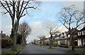
Streetsbrook Road, B4025, Crossing Birmingham - Marylebone Railway Line
Image: © Roy Hughes
Taken: 31 May 2011
0.12 miles
2

OS benchmark - Solihull, Streetsbrook Rd bridge
An OS cutmark on the buttress at the west end of the bridge over the railway; originally levelled at 135.87m above Ordnance Datum Newlyn.
Image: © Richard Law
Taken: 16 Apr 2014
0.12 miles

4

OS benchmark - Shirley, 409 Streetsbrook Road
A heavily-painted OS cutmark low on the front wall of no 409 Streetsbrook Road; originally levelled at 134.45m above Ordnance Datum Newlyn.
Image: © Richard Law
Taken: 7 Sep 2016
0.15 miles
6

Up the line towards Solihull station
From the Streetsbrook Road bridge, along the railway line, in the direction of the town centre and station.
Image: © Richard Law
Taken: 16 Apr 2014
0.19 miles
7

OS benchmark - Worlds End, 490 Warwick Road
An OS cutmark on the side wall of no 490 Warwick Road; originally levelled at 132.54m above Ordnance Datum Newlyn.
Image: © Richard Law
Taken: 20 Mar 2015
0.20 miles
8
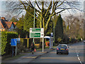
Warwick Road, Solihull
The advance direction sign, just before the bus stop, has the white background with black borders and direction arrows associated with a non-primary route. The destinations are, however, on green patches with white lettering; this is because the road is joining a primary route (the A41, Seven Star Road). Note the use of the small pictogram (silhouette of an aircraft) to represent Birmingham Airport instead of displaying the full name.
Image: © David Dixon
Taken: 21 Dec 2012
0.20 miles
9
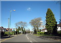
Warwick Road Approaching Seven Star Road Solihull
Image: © Roy Hughes
Taken: 7 Mar 2016
0.20 miles
10
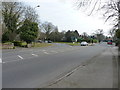
At the junction of Warwick Road and Seven Star Road
Traffic lights at the junction. Straight on, the B425 Warwick Road leads into Solihull, whilst the A41 Seven Star Road bypasses Solihull to the north, before heading to the M42 at junction 5.
Image: © Richard Law
Taken: 20 Mar 2015
0.22 miles