IMAGES TAKEN NEAR TO
Rockville Road, BIRMINGHAM, B8 3DU
Introduction
This page details the photographs taken nearby to Rockville Road, B8 3DU by members of the Geograph project.
The Geograph project started in 2005 with the aim of publishing, organising and preserving representative images for every square kilometre of Great Britain, Ireland and the Isle of Man.

There are currently over 7.5m images from over14,400 individuals and you can help contribute to the project by visiting https://www.geograph.org.uk
Image Map
Images are licensed for reuse under creativecommons.org/licenses/by-sa/2.0
Notes
- Clicking on the map will re-center to the selected point.
- The higher the marker number, the further away the image location is from the centre of the postcode.
Image Listing (4 Images Found)
Images are licensed for reuse under creativecommons.org/licenses/by-sa/2.0
Image
Details
Distance
1
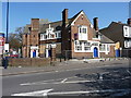
The Brookhill pub
Currently closed, and up for let according to the signage. It lies at the junction of Alum Rock Road with Brook Hill Road.
Image: © Richard Law
Taken: 21 Apr 2015
0.08 miles
2
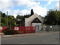
Church of God of Prophecy
The Church of God of Prophecy is based in Cleveland, Tennessee, and claims a worldwide membership of over 1,500,000
Image: © Keith Edkins
Taken: 17 Sep 2011
0.08 miles
3
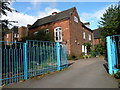
St John's House, Alum Rock Road
Home of the (Anglican) Community of St John the Divine
Image: © Keith Edkins
Taken: 17 Sep 2011
0.21 miles
4
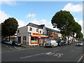
Shops in Alum Rock Road
The Roti & Curry Bazaar heads this row of shops at the junction of Sandbourne Road
Image: © Keith Edkins
Taken: 17 Sep 2011
0.24 miles