IMAGES TAKEN NEAR TO
Kiln Rise, BIRMINGHAM, B8 3AW
Introduction
This page details the photographs taken nearby to Kiln Rise, B8 3AW by members of the Geograph project.
The Geograph project started in 2005 with the aim of publishing, organising and preserving representative images for every square kilometre of Great Britain, Ireland and the Isle of Man.

There are currently over 7.5m images from over14,400 individuals and you can help contribute to the project by visiting https://www.geograph.org.uk
Image Map
Images are licensed for reuse under creativecommons.org/licenses/by-sa/2.0
Notes
- Clicking on the map will re-center to the selected point.
- The higher the marker number, the further away the image location is from the centre of the postcode.
Image Listing (7 Images Found)
Images are licensed for reuse under creativecommons.org/licenses/by-sa/2.0
Image
Details
Distance
1

Saltley Pentecostal City Mission Church
Alternatively known as the Birmingham City Mission, this was originally St John's mission room, an offshoot of Image roughly half a mile to the west, and was built in 1935. As congregations dwindled, it fell out of use by 2010, but was adopted in 2013 by the Pentecostal City Mission organisation, and reopened soon after that.
Image: © Richard Law
Taken: 21 Apr 2015
0.12 miles
2

OS benchmark - Saltley, Shaw Hill Primary School
An OS cutmark on the west-facing wall of the school, at the corner of Alum Rock Road and Anthony Road. Originally levelled at 111.61m above Ordnance Datum Newlyn.
Image: © Richard Law
Taken: 21 Apr 2015
0.12 miles
3

West end of Gowan Road, Saltley
With part of a large flock of feral pigeons (rock doves) milling around the turning area.
Image: © Richard Vince
Taken: 3 Dec 2022
0.17 miles
4

Flock of pigeons, Gowan Road, Saltley
A sizeable gathering of feral pigeons (rock doves) pecks around the turning area at the closed off end of Gowan Road, where it formerly met Highfield Road and Alum Rock Road.
Image: © Richard Vince
Taken: 3 Dec 2022
0.18 miles
5
Highfield Road, Saltley
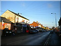
Looking towards Washwood Heath from near its junction with Alum Rock Road.
Image: © Richard Vince
Taken: 3 Dec 2022
0.20 miles
6
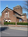
Saltley Catholic Church
The Catholic Church of Our Lady of the Rosary and St Therese, which sits on Bridge Road, Saltley. Originally built in 1931 to serve the needs of a growing Catholic population, it was extensively damaged during the war, and lost walls and a large window. It was rebuilt in 1942/43. It is now part of the Archdiocese of Birmingham.
Image: © Richard Law
Taken: 21 Apr 2015
0.21 miles
7

Havelock Road, Saltley
Off Highfield Road.
Image: © Richard Vince
Taken: 3 Dec 2022
0.24 miles