IMAGES TAKEN NEAR TO
St. Agathas Road, BIRMINGHAM, B8 2TU
Introduction
This page details the photographs taken nearby to St. Agathas Road, B8 2TU by members of the Geograph project.
The Geograph project started in 2005 with the aim of publishing, organising and preserving representative images for every square kilometre of Great Britain, Ireland and the Isle of Man.

There are currently over 7.5m images from over14,400 individuals and you can help contribute to the project by visiting https://www.geograph.org.uk
Image Map (Loading...)


Getting Data...Please wait
Leaflet Map data © OpenStreetMap
Images are licensed for reuse under creativecommons.org/licenses/by-sa/2.0
Notes
- Clicking on the map will re-center to the selected point.
- The higher the marker number, the further away the image location is from the centre of the postcode.
Image Listing (17 Images Found)
Images are licensed for reuse under creativecommons.org/licenses/by-sa/2.0
Image
Details
Distance
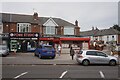
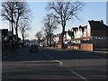
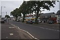
1
Washwood Heath Road at Agatha's Road, Birmingham
Image: © Ian S
Taken: 26 Jul 2021
0.07 miles
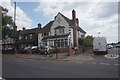
2
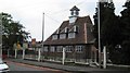
Thornton Primary School
In Thornton Road, Ward End - distinctive clock tower and roof
Image: © Michael Westley
Taken: 5 Jun 2010
0.08 miles
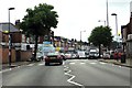
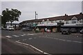
4
Washwood Heath Road west of Foley Road
Image: © Peter Whatley
Taken: 11 Feb 2012
0.13 miles
7
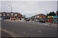
Woodwell's Road off Alum Rock Road, Birmingham
Image: © Ian S
Taken: 23 Jul 2021
0.15 miles
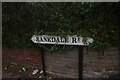
9
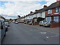
William Cook Road, Ward End
Terraced housing along the length of William Cook Road.
Image: © Richard Law
Taken: 22 Jul 2015
0.16 miles