IMAGES TAKEN NEAR TO
St. Saviours Road, BIRMINGHAM, B8 1ER
Introduction
This page details the photographs taken nearby to St. Saviours Road, B8 1ER by members of the Geograph project.
The Geograph project started in 2005 with the aim of publishing, organising and preserving representative images for every square kilometre of Great Britain, Ireland and the Isle of Man.

There are currently over 7.5m images from over14,400 individuals and you can help contribute to the project by visiting https://www.geograph.org.uk
Image Map
Images are licensed for reuse under creativecommons.org/licenses/by-sa/2.0
Notes
- Clicking on the map will re-center to the selected point.
- The higher the marker number, the further away the image location is from the centre of the postcode.
Image Listing (37 Images Found)
Images are licensed for reuse under creativecommons.org/licenses/by-sa/2.0
Image
Details
Distance
1
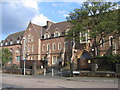
St Peter's College buildings
St Peter's College of Education was founded by Charles Bowyer Adderley, K.C.M.G., first Lord Norton, in 1852. Today these buildings from the college are managed by the St Peter's Housing association providing social housing for rent including, sheltered housing for the elderly.
Image: © David Stowell
Taken: 23 Sep 2006
0.07 miles
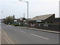
2
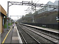
Adderley Park railway station
The train departing is the 09.39 local service from Birmingham New Street.
Image: © Peter Whatley
Taken: 29 Mar 2011
0.15 miles
3
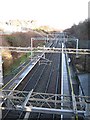
Adderley Park Station
Inner city railway station, first station from New Street on route to Coventry and London. Very straight section of line out towards Stechford.
Image: © Michael Westley
Taken: 26 Dec 2009
0.16 miles
4
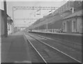
Adderley Park Station
View from trackside of platforms. Compare this to 'today' Image] and some of the platform architecture remains. Notice however on the left, the 'Ticket Office' was then at platform level.
Notice the tall arched bridge in background - see Image] for view towards station from there.
Image: © Michael Westley
Taken: Unknown
0.16 miles
5
Adderley Park railway station - street view
Image: © Peter Whatley
Taken: 29 Mar 2011
0.16 miles
6
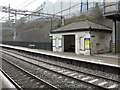
Adderley Park railway station - down side shelter
A rather austere structure for Birmingham-bound passengers.
Image: © Peter Whatley
Taken: 29 Mar 2011
0.17 miles
7
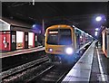
Birmingham train arrives at Adderley Park
Image: © Roger Cornfoot
Taken: 7 Jan 2017
0.18 miles
8
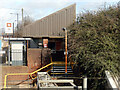
Adderley Park Station
This view is looking across from the steps leading to the down platform to the ticket office building. The small inner city station - the first stop on the line out of Birmingham towards Coventry - was opened in 1860. The Adderley name derives from Sir Charles Adderley who became lord of the manor in the 17th century; it is believed that he built a new manor house, Saltley Hall, that is known to have survived until the 1940s. Adderley's descendants were responsible for developing the area with rows of terraced houses in Victorian times, many of them occupied by railway workers, and the family remained major landowners in the area into the 20th century. They also opened a park, Adderley Park, in 1855 which later passed to Birmingham town council.
Image: © Stephen McKay
Taken: 9 Mar 2022
0.18 miles
9
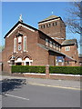
Saltley Catholic Church
The Catholic Church of Our Lady of the Rosary and St Therese, which sits on Bridge Road, Saltley. Originally built in 1931 to serve the needs of a growing Catholic population, it was extensively damaged during the war, and lost walls and a large window. It was rebuilt in 1942/43. It is now part of the Archdiocese of Birmingham.
Image: © Richard Law
Taken: 21 Apr 2015
0.18 miles
10
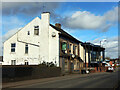
The Station Hotel, Saltley
The sign over the door of the Station Hotel on Bordesley Park Road depicts a jolly fellow enjoying his pint of William Younger's beer. Sadly he can no longer enjoy his beer, or anything else, at this firmly boarded-up old pub. Despite its location on a main road opposite Adderley Park station it closed down probably around 2009, a victim of changing fashion and demographic trends. There are of course many similar pubs across the country that have succumbed over the last 20 years or so, but this seems especially the case in Birmingham's inner eastern suburbs with their significant Muslim community. See Image for a 2015 view.
Image: © Stephen McKay
Taken: 9 Mar 2022
0.18 miles