IMAGES TAKEN NEAR TO
Mildenhall, TAMWORTH, B79 8RU
Introduction
This page details the photographs taken nearby to Mildenhall, B79 8RU by members of the Geograph project.
The Geograph project started in 2005 with the aim of publishing, organising and preserving representative images for every square kilometre of Great Britain, Ireland and the Isle of Man.

There are currently over 7.5m images from over14,400 individuals and you can help contribute to the project by visiting https://www.geograph.org.uk
Image Map
Images are licensed for reuse under creativecommons.org/licenses/by-sa/2.0
Notes
- Clicking on the map will re-center to the selected point.
- The higher the marker number, the further away the image location is from the centre of the postcode.
Image Listing (17 Images Found)
Images are licensed for reuse under creativecommons.org/licenses/by-sa/2.0
Image
Details
Distance

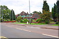
4
Bridge taking Ashby Road (B5493) over railway
Ordnance Survey records indicate that in 1964 a benchmark levelled at 80.614m above Newlyn Datum was verified on the left hand parapet over the centre of the railway.
Image: © Roger Templeman
Taken: 3 Aug 2017
0.13 miles
5
Railway Bridge
This bridge carries the B5493 over the Tamworth to Burton line.
Image: © Michael Patterson
Taken: 16 Feb 2006
0.14 miles
6
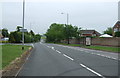
Ashby Road (B5493) heading NE
There is a milestone Image on the verge beside a lamppost displaying the road name and speed camera warning
Image: © Roger Templeman
Taken: 3 Aug 2017
0.14 miles
7
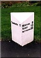
Old Milepost, B5493 (was A453), Ashby Road, Perry Crofts
The milestone is located in the pavement on the south east side of the road. Parish of Tamworth (Tamworth District) Cast iron post, Cochrane iron casting design, erected by the County Council in the 20th century.
Inscription reads:-
: TAMWORTH 1 : : MEASHAM 9 / ASHBY 13 / NOTTINGHAM 35 :
Maker:-
: Cochrane & Co, Dudley. :
Staffordshire HER.
HER Number: 51424 https://www.heritagegateway.org.uk/Gateway/Results_Single.aspx?uid=MST12694&resourceID=1010
Milestone Society National ID: ST_TMNT01
Image: © J Higgins
Taken: Unknown
0.14 miles
8
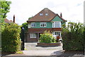
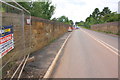
'Conigre', #64 Ashby Road
Ordnance Survey documents indicate that in 1964 a benchmark levelled at 90.870m above Newlyn Datum was verified on a detached garage (since demolished) to the right of the house
Image: © Roger Templeman
Taken: 3 Aug 2017
0.14 miles
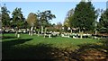
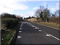
10
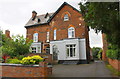
#75 (Wetherby Lodge) and #77 (Suffield Lodge), Wiggington Road
Ordnance Survey documents indicate that in 1956 a benchmark was levelled at 90.418m above Newlyn Datum on the side of the right hand house 4.6m back from its front corner
Image: © Roger Templeman
Taken: 3 Aug 2017
0.20 miles