IMAGES TAKEN NEAR TO
Chestnut Avenue, TAMWORTH, B79 8QX
Introduction
This page details the photographs taken nearby to Chestnut Avenue, B79 8QX by members of the Geograph project.
The Geograph project started in 2005 with the aim of publishing, organising and preserving representative images for every square kilometre of Great Britain, Ireland and the Isle of Man.

There are currently over 7.5m images from over14,400 individuals and you can help contribute to the project by visiting https://www.geograph.org.uk
Image Map
Images are licensed for reuse under creativecommons.org/licenses/by-sa/2.0
Notes
- Clicking on the map will re-center to the selected point.
- The higher the marker number, the further away the image location is from the centre of the postcode.
Image Listing (14 Images Found)
Images are licensed for reuse under creativecommons.org/licenses/by-sa/2.0
Image
Details
Distance
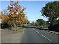
1
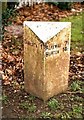
Old Milepost by the A513 in Tamworth
Cast iron post by the A513, in parish of Tamworth (Tamworth District), roadside, on the verge, on North East side of road. Cochrane iron casting, erected by the County Council in the 20th century.
Inscription reads:-
: TAMWORTH 1 : : ALREWAS 7½ / BURTON 14½ :
Maker:-
: Cochrane & Co, Dudley. :
Milestone Society National ID: ST_TMBT01
Image: © J Higgins
Taken: 1 Jan 2001
0.05 miles
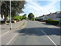
2
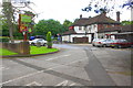
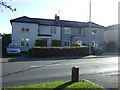
Entrance to Riftswood pub from Comberford Road
Ordnance Survey documents indicate that in 1961 a benchmark levelled at 77.370m above Newlyn Datum was verified on a roadside wall at the right hand side of this entrance
Image: © Roger Templeman
Taken: 3 Aug 2017
0.10 miles
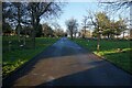
3
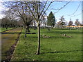
Cemetery Drive
Wigginton Road Cemetery in Tamworth has a date of 1914 on the gate.
Image: © Michael Patterson
Taken: 28 Feb 2006
0.15 miles
4
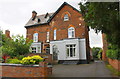
#75 (Wetherby Lodge) and #77 (Suffield Lodge), Wiggington Road
Ordnance Survey documents indicate that in 1956 a benchmark was levelled at 90.418m above Newlyn Datum on the side of the right hand house 4.6m back from its front corner
Image: © Roger Templeman
Taken: 3 Aug 2017
0.17 miles
5
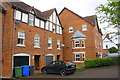
New housing on the west side of Wiggington Road
Ordnance Survey documents indicate that in 1956 a benchmark was levelled at 90.443m above Newlyn Datum at this location on St Editha's hospital. The building was originally (1859) a workhouse, later became St Editha's Hospital and closed in 1998, with many of the buildings demolished and the site developed for residential use
Image: © Roger Templeman
Taken: 3 Aug 2017
0.18 miles
10
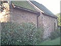
The Spital Chapel
This is the oldest building in Tamworth, possibly partly pre-Norman conquest. It is still used as a Church and has been a Monastery Chapel, a private house, a barn and eventually restored as a place of worship
Image: © Ian Cardinal
Taken: 7 Apr 2004
0.21 miles