IMAGES TAKEN NEAR TO
The Chase, SUTTON COLDFIELD, B76 1JS
Introduction
This page details the photographs taken nearby to The Chase, B76 1JS by members of the Geograph project.
The Geograph project started in 2005 with the aim of publishing, organising and preserving representative images for every square kilometre of Great Britain, Ireland and the Isle of Man.

There are currently over 7.5m images from over14,400 individuals and you can help contribute to the project by visiting https://www.geograph.org.uk
Image Map
Images are licensed for reuse under creativecommons.org/licenses/by-sa/2.0
Notes
- Clicking on the map will re-center to the selected point.
- The higher the marker number, the further away the image location is from the centre of the postcode.
Image Listing (42 Images Found)
Images are licensed for reuse under creativecommons.org/licenses/by-sa/2.0
Image
Details
Distance
1
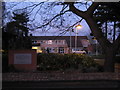
Church of Latter Day Saints, Penns Lane, Walmley
Apart from being a place of worship for the church, the site is also a location for family tree searches for Birmingham and the Midlands for the general public.
Image: © Michael Westley
Taken: 20 Dec 2009
0.08 miles
2
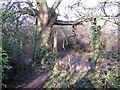
Remains of fence, right of way, Walmley
On right of way and footpath, between football ground and edge of Walmley Golf Course, there appears the remains of an old fence or sign.
Image: © Michael Westley
Taken: 26 Dec 2009
0.11 miles
3
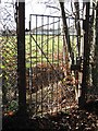
Gated access to football pitch, Walmley
View from right of way in tree-lined footpath running along edge of Walmley Golf Course shortly before/after reaching/leaving the golf course. Football pitches are accessed from Foxlands Drive.
Image: © Michael Westley
Taken: 26 Dec 2009
0.11 miles
4
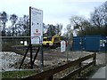
Major Works, Penns Lane
Work in progress in grounds of Ramada Penns Hall Hotel, being plans for new walking and cycling route between Castle Vale and Sutton Coldfield.
Image: © Michael Westley
Taken: 6 Mar 2010
0.12 miles
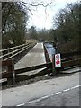
5
Plants Brook and new cycle route
New Sustrans route and permissive footpath through grounds of Ramada Hotel, Penns Lane. View as route crosses Plants Brook, close to Seb Coe Sports Club in grounds of hotel
Image: © Michael Westley
Taken: 22 May 2010
0.12 miles
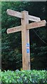
6

New Cycle Route and signs, Penns Lane
At entrance to Ramada Hotel (Penns Hall Hotel to you and me), there is now a 'permissive' cycle route and footpath through the grounds of the hotel, along Plants Brook - a new sign indicates the distances to prominent places.
Image: © Michael Westley
Taken: 22 May 2010
0.13 miles
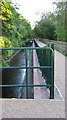
7
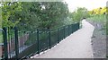
Cycle Route completed, Penns Hall
A nice new cycle route alongside Plants Brook, in grounds of the hotel, is now completed. Running from Penns Lane north to New Hall Valley. Sustran 534
Image] part completed.
Image: © Michael Westley
Taken: 22 May 2010
0.13 miles
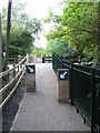
8
New Cycle Route and Sign, Penns Lane
A new cycle route has been built alongside Plants Brook, part of an extensive new route between Sutton Coldfield and (eventually) Castle Vale - Sustran 534
Passing trade was perhaps on the hotel's mind, as well as helping the environment and people's health
Image: © Michael Westley
Taken: 22 May 2010
0.13 miles
9
New cycling route at Penns Lane
Plans are well in hand for creation of new cycling and walking route through the grounds of Ramada Penns Hall Hotel, Penns Lane. The track running off to the right is the driveway to the hotel.
Image: © Michael Westley
Taken: 6 Mar 2010
0.13 miles
10
Sustrans Cycle Route, Penns Hall Hotel
Through the grounds of the hotel a new Sustrans route has been created from New Hall Country Park to Penns Lane. View from where route crosses Plants Brook, near Seb Coe Health Club
Image: © Michael Westley
Taken: 22 May 2010
0.14 miles