IMAGES TAKEN NEAR TO
Carroway Head, SUTTON COLDFIELD, B75 5RY
Introduction
This page details the photographs taken nearby to Carroway Head, B75 5RY by members of the Geograph project.
The Geograph project started in 2005 with the aim of publishing, organising and preserving representative images for every square kilometre of Great Britain, Ireland and the Isle of Man.

There are currently over 7.5m images from over14,400 individuals and you can help contribute to the project by visiting https://www.geograph.org.uk
Image Map
Images are licensed for reuse under creativecommons.org/licenses/by-sa/2.0
Notes
- Clicking on the map will re-center to the selected point.
- The higher the marker number, the further away the image location is from the centre of the postcode.
Image Listing (5 Images Found)
Images are licensed for reuse under creativecommons.org/licenses/by-sa/2.0
Image
Details
Distance
1
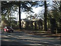
Gatehouse to Canwell Hall
On A453,Carroway Head Hill
Image: © Michael Westley
Taken: 11 Feb 2012
0.00 miles
2
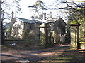
Gatehouse to Canwell Hall
Gatehouse at entrance to grounds of Canwell Hall, and remains of old priory
Image: © Michael Westley
Taken: 11 Feb 2012
0.00 miles
3
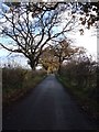
Shirrall Drive, Carroway Head
Shirrall Drive runs due East from Carroway Head to Shirrall Hall Farm. This photograph was taken near to Carroway Head Farm.
Image: © Rob Farrow
Taken: 26 Nov 2006
0.06 miles
4
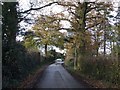
Carroway Head
This is the end of Shirrall Drive at Carroway Head. Carroway Head Farm is on the left. The car is on the A453 as it crosses the end of the lane.
Image: © Rob Farrow
Taken: 26 Nov 2006
0.06 miles
5
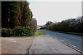
Looking along the A453 in the direction of Fazeley
Image: © Mick Malpass
Taken: 25 Feb 2012
0.15 miles