IMAGES TAKEN NEAR TO
Great Lister Street, BIRMINGHAM, B7 4DB
Introduction
This page details the photographs taken nearby to Great Lister Street, B7 4DB by members of the Geograph project.
The Geograph project started in 2005 with the aim of publishing, organising and preserving representative images for every square kilometre of Great Britain, Ireland and the Isle of Man.

There are currently over 7.5m images from over14,400 individuals and you can help contribute to the project by visiting https://www.geograph.org.uk
Image Map
Images are licensed for reuse under creativecommons.org/licenses/by-sa/2.0
Notes
- Clicking on the map will re-center to the selected point.
- The higher the marker number, the further away the image location is from the centre of the postcode.
Image Listing (189 Images Found)
Images are licensed for reuse under creativecommons.org/licenses/by-sa/2.0
Image
Details
Distance
1
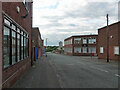
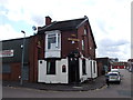
Windsor Street, Birmingham (1)
A street of low-rise light industrial buildings and related offices mostly looking as if they were put up in the 1950s or 1960s.
Image: © Stephen Richards
Taken: 21 Jun 2015
0.02 miles
3
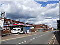
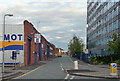
Lord Street, Birmingham
Mostly lined with low-rise light industrial buildings and related offices mostly looking as if they were put up in the 1950s or 1960s. On the left are the now-dismantled gas holders of the former gas works.
Image: © Stephen Richards
Taken: 21 Jun 2015
0.06 miles
4
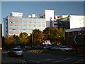
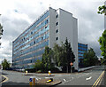
Waterlinks House
Built in the sixties as a 'flatted factory' the building housed numerous small industrial units. It has now been converted into office accommodation.
Image: © Graham Taylor
Taken: 10 Oct 2005
0.08 miles
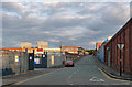
5
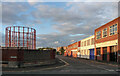
Adams Street, Birmingham
Plenty of car-related activity.
On the right is Image
Image: © Stephen Richards
Taken: 21 Jun 2015
0.08 miles
6
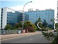
Waterlinks House, Richard Street, Birmingham
A 1960s office block.
Since this photo it has become the King Solomon International Business School and been horribly re-clad.
Image: © Stephen Richards
Taken: 21 Jun 2015
0.09 miles
7
Waterlinks House, Dartmouth Middleway, Birmingham
Built in the sixties as a 'flatted factory' the building housed numerous small industrial units. It has now been converted into office accommodation.
Image: © Graham Taylor
Taken: 10 Oct 2005
0.09 miles
9
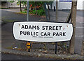
Street sign, Adams Street, Birmingham
For "Adams Street / Public Car Park / Public Works Department". It looks as if it might date from the 1960s. The PWD must be long gone.
Image: © Stephen Richards
Taken: 21 Jun 2015
0.10 miles
10
Windsor Street, Birmingham (2)
A street of low-rise light industrial buildings and related offices mostly looking as if they were put up in the 1950s or 1960s.
Image: © Stephen Richards
Taken: 21 Jun 2015
0.11 miles