IMAGES TAKEN NEAR TO
Blake Street, SUTTON COLDFIELD, B74 4EZ
Introduction
This page details the photographs taken nearby to Blake Street, B74 4EZ by members of the Geograph project.
The Geograph project started in 2005 with the aim of publishing, organising and preserving representative images for every square kilometre of Great Britain, Ireland and the Isle of Man.

There are currently over 7.5m images from over14,400 individuals and you can help contribute to the project by visiting https://www.geograph.org.uk
Image Map
Images are licensed for reuse under creativecommons.org/licenses/by-sa/2.0
Notes
- Clicking on the map will re-center to the selected point.
- The higher the marker number, the further away the image location is from the centre of the postcode.
Image Listing (44 Images Found)
Images are licensed for reuse under creativecommons.org/licenses/by-sa/2.0
Image
Details
Distance
1

Old Milepost by the B4026, Blake Street, Watford Gap, Shenstone Parish
Cast iron post by the A4026, in parish of SHENSTONE (LICHFIELD District), Watford Gap, between junction with the A5127 and Blake Street Station, between path and hedge, on North side of road, in front of No.26. Lathe iron casting, erected by the County Council in the 19th/20th century.
Inscription reads:-
: TAMWORTH / 8 : : SHENSTONE : : LITTLE - / ASTON 1¼ / ALDRIDGE 3¼ / WALSALL 7 :
Maker:-
: Chas. Lathe, Tipton. :
Milestone Society National ID: ST_WLTM07.
Image: © J Higgins
Taken: 1 Jan 2001
0.03 miles
3
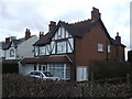
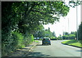
Blake Street (A4026)
Approaching roundabout.
Image: © JThomas
Taken: 18 Apr 2013
0.08 miles
7
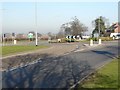
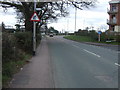
A 5127, Watford Gap, Traffic Island
Although shown on OS maps as a crossroads the junction has been an island for several years, following a number of fatal accidents at the junction.
Image: © Graham Taylor
Taken: 12 Feb 2008
0.13 miles
8
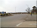
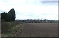
Watford Gap Road
The junction with the A5127 Lichfield Road on the Staffordshire Border.
Image: © Gordon Griffiths
Taken: 7 Apr 2013
0.14 miles
10
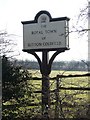
Sutton Coldfield Town Sign, Watford Gap A5127
There were similar signs on all main roads, at the boundary of the town of Sutton Coldfield. In 1974 Sutton Coldfield became part of Birmingham and the city council removed the Sutton Coldfield signs. Since then some have been purchased by private individuals and placed on private land as close as possible to their original locations. This particular one was about 1 metre closer to the camera.
See also Image for updated information.
Image: © Graham Taylor
Taken: 12 Feb 2008
0.14 miles