IMAGES TAKEN NEAR TO
Little Green Lanes, SUTTON COLDFIELD, B73 5NB
Introduction
This page details the photographs taken nearby to Little Green Lanes, B73 5NB by members of the Geograph project.
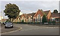
The Geograph project started in 2005 with the aim of publishing, organising and preserving representative images for every square kilometre of Great Britain, Ireland and the Isle of Man.

There are currently over 7.5m images from over14,400 individuals and you can help contribute to the project by visiting https://www.geograph.org.uk
Image Map
Images are licensed for reuse under creativecommons.org/licenses/by-sa/2.0
Notes
- Clicking on the map will re-center to the selected point.
- The higher the marker number, the further away the image location is from the centre of the postcode.
Image Listing (102 Images Found)
Images are licensed for reuse under creativecommons.org/licenses/by-sa/2.0
Image
Details
Distance
1
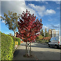
Sweet Gum, Little Green Lanes, Wylde Green
Sweet Gum, or Liquidambar styraciflua is occasionally seen as a street tree in the area, its vivid autumn colour catching the eye.
Image: © Robin Stott
Taken: 16 Oct 2022
0.02 miles
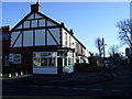
2
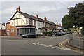
Little Green Lanes, Wylde Green, northeast Birmingham
The dental surgery on the corner calls itself 'nothing but the tooth'. Out of shot, right, is Wylde Green Primary School Image
Image: © Robin Stott
Taken: 23 Jun 2018
0.03 miles
3
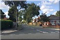
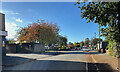
Emmanuel Road, Wylde Green, north Birmingham
A residential road running north from Little Green Lanes.
Image: © Robin Stott
Taken: 19 Aug 2019
0.04 miles
4
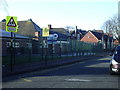
Wylde Green Primary School
Wylde Green's first school, opened in 1840 when the population of Wylde Green was only 60.
The school has been extended in the last few years (buildings on left). View is from Little Green Lanes looking west.
Image: © Michael Westley
Taken: 1 Jan 2010
0.04 miles
5
Wylde Green Primary School, Little Green Lanes, northeast Birmingham
Old maps show a smaller school building here by 1889 when the area was still a mosaic of piecemeal residential development and small fields. Houses on the south side of Little Green Lanes would have looked out over farmland. By 1914 there were two schools with a few houses opposite. By 1937 the whole area to the north was solidly residential. By 1963 the two schools had been connected to form one County Primary School.
Image: © Robin Stott
Taken: 23 Jun 2018
0.05 miles
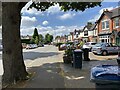
6
West on Little Green Lanes, B73
On the left is the rear service road to a parade of shops; further along, Emscote Gardens; beyond that, Wylde Green Primary School and Green Lanes itself.
Image: © Robin Stott
Taken: 17 Oct 2022
0.05 miles
7
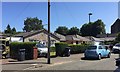
Bungalows, Little Green Lanes, Wylde Green, north Birmingham
Image: © Robin Stott
Taken: 27 Jun 2018
0.06 miles
8
Houses, trees and cars along Green Lanes, Wylde Green, northeast Birmingham
Image: © Robin Stott
Taken: 23 Jun 2018
0.06 miles
9
Dental Practice, Little Green Lanes, Sutton Coldfield
Corner of Little Green Lanes and Green Lanes, opposite primary school.
Image: © Michael Westley
Taken: 1 Jan 2010
0.06 miles
10
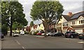
South on Green Lanes, Wylde Green, north Birmingham
These were the first suburban houses on Green Lanes, dating from the Edwardian years. It was solidly built up with detached and semi-detached houses by 1937, going by old-maps.co.uk. The south end of Green Lanes had been severed by the L & NWR's Sutton Coldfield Branch: the necessary realignment gave the slight change of direction of the road, seen in the distance. Big old trees tell of an earlier undeveloped suburb when much of Green Lanes was a country lane between fields and allotment gardens.
Image: © Robin Stott
Taken: 14 Jul 2021
0.06 miles