IMAGES TAKEN NEAR TO
South Road, SMETHWICK, B67 7BP
Introduction
This page details the photographs taken nearby to South Road, B67 7BP by members of the Geograph project.
The Geograph project started in 2005 with the aim of publishing, organising and preserving representative images for every square kilometre of Great Britain, Ireland and the Isle of Man.

There are currently over 7.5m images from over14,400 individuals and you can help contribute to the project by visiting https://www.geograph.org.uk
Image Map
Images are licensed for reuse under creativecommons.org/licenses/by-sa/2.0
Notes
- Clicking on the map will re-center to the selected point.
- The higher the marker number, the further away the image location is from the centre of the postcode.
Image Listing (69 Images Found)
Images are licensed for reuse under creativecommons.org/licenses/by-sa/2.0
Image
Details
Distance
1
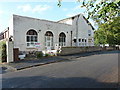
Smethwick ex-Servicemen's Club Ltd
Located on South Road, and judging by the fence and signage, this pub/club is due for demolition and redevelopment in the non-too-distant future.
Image: © Richard Law
Taken: 11 Aug 2014
0.02 miles
5
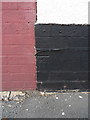
OS benchmark - Smethwick, 4 Holly Street
A heavily overpainted OS cutmark on the wall of no 4 Holly Street; originally levelled at 166.768m above Ordnance Datum Newlyn.
Image: © Richard Law
Taken: 11 Aug 2014
0.09 miles
6
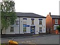
Deepika Travels, 16-18 South Road
This is the Smethwick Office of Deepika Travels, a travel agent. It is an agent for Turkmenistan Airlines.
Image: © P L Chadwick
Taken: 16 Aug 2010
0.11 miles
8
Ordnance Survey benchmark on Holy Trinity Church
Ordnance Survey benchmark on Holy Trinity Church levelled with a height of 163.1869m above sea level at Newlyn. To the left of it is a smaller unidentified mark.
Image: © Shantavira
Taken: 28 Jan 2012
0.12 miles
9
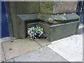
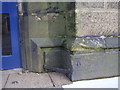
OS benchmark - Smethwick, Holy Trinity church
An OS cutmark (along with something that is probably the building mason's mark to its left) near the doorway of Holy Trinity church in the centre of Smethwick. Originally levelled at 163.187m above Ordnance Datum Newlyn.
Image: © Richard Law
Taken: 11 Aug 2014
0.12 miles
10
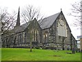
Holy Trinity Church
The original church on the present site was consecrated in 1838 as a chapel of ease to the ancient parish of Harbourne. Four years later the parish was divided into two, and Holy Trinity became a parish church in its own right.Smethwick grew rapidly in the second half of the 19th century. In 1888 most of the original church was rebuilt, using much of the Tixall stone, but on a larger scale to seat over 800 people. Until Smethwick lost its status as a County Borough in 1966, Holy Trinity had a major involvement in the civic life of the borough and the Civic Service was held here on 'Mayor's Sunday' every year.
Image: © Stephen Rogerson
Taken: 16 Feb 2012
0.12 miles