IMAGES TAKEN NEAR TO
St. Georges Drive, SMETHWICK, B66 1DN
Introduction
This page details the photographs taken nearby to St. Georges Drive, B66 1DN by members of the Geograph project.
The Geograph project started in 2005 with the aim of publishing, organising and preserving representative images for every square kilometre of Great Britain, Ireland and the Isle of Man.

There are currently over 7.5m images from over14,400 individuals and you can help contribute to the project by visiting https://www.geograph.org.uk
Image Map
Images are licensed for reuse under creativecommons.org/licenses/by-sa/2.0
Notes
- Clicking on the map will re-center to the selected point.
- The higher the marker number, the further away the image location is from the centre of the postcode.
Image Listing (121 Images Found)
Images are licensed for reuse under creativecommons.org/licenses/by-sa/2.0
Image
Details
Distance
1
Smethwick Brasshouse Lane Passing School Playing Field
Image: © Roy Hughes
Taken: 1 Jan 2018
0.04 miles
4
The Albion Foundation
The Albion Foundation on Brasshouse Lane. Looking like a closed pub I think this is West Bromwich Albion's Foundation School.
Image: © Philip Halling
Taken: 14 Jul 2018
0.12 miles
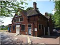
5
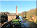
Smethwick New Pumping Station
Completed in 1892 by the Birmingham Canal Navigation Company
Image: © Roy Hughes
Taken: 1 Jan 2018
0.16 miles
6
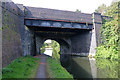
Birmingham Canal Navigations - Brasshouse Lane Bridge
This bridge is over the Old Main Line at Brasshouse Lane and has clearly been widened. Just through the other side is the Smethwick New Pumping Station.
Image: © Chris Allen
Taken: 14 Sep 2019
0.16 miles
7
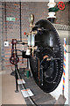
Smethwick New Pump House - boiler
This building was erected in 1892 with a pair of Drysdale compound engines driving centrifugal pumps. It pumped between the New Main Line and Old Main Lines to replace water lost by lockage. It replaced the old pumping station and its beam engines, one of which was a Boulton & Watt engine of 1779. The pump house was derelict but Sandwell Council restored the building, rebuilt the chimney and installed a Tangye pumping engine along with one and a bit boilers. This is the complete boiler and although it is never going to work the installation is quite convincing.
Image: © Chris Allen
Taken: 14 Sep 2019
0.17 miles
8
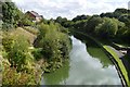
BCN Old Main Line - view from Brasshouse Lane Bridge
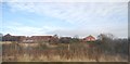
The 1000 yard Smethwick Summit level of Brindley's original contour canal would have been at the level of the housing estate on left. Difficulties with supplying water at this level led to a new cut to a Smeaton design eighteen feet lower. Telford's later New Main Line is cut a further eighteen feet lower behind the trees on the right.
Image: © John M
Taken: 11 Sep 2016
0.17 miles
10
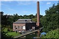
New Smethwick Pumping Station - Brasshouse Lane
The pumping station opened in 1892 to lift water from Telford's New Main Line to the higher Old Main Line to restore water lost from operation of the Spon Lane and Smethwick Locks. The station which replaced two Boulton and Watt pumping engines also became redundant as canal usage reduced in the 1920s.
Image: © John M
Taken: 11 Sep 2016
0.17 miles