IMAGES TAKEN NEAR TO
Birch Drive, HALESOWEN, B62 9HU
Introduction
This page details the photographs taken nearby to Birch Drive, B62 9HU by members of the Geograph project.
The Geograph project started in 2005 with the aim of publishing, organising and preserving representative images for every square kilometre of Great Britain, Ireland and the Isle of Man.

There are currently over 7.5m images from over14,400 individuals and you can help contribute to the project by visiting https://www.geograph.org.uk
Image Map (Loading...)


Getting Data...Please wait
Leaflet Map data © OpenStreetMap
Images are licensed for reuse under creativecommons.org/licenses/by-sa/2.0
Notes
- Clicking on the map will re-center to the selected point.
- The higher the marker number, the further away the image location is from the centre of the postcode.
Image Listing (31 Images Found)
Images are licensed for reuse under creativecommons.org/licenses/by-sa/2.0
Image
Details
Distance
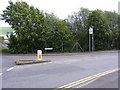
1
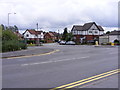
Douglas Road Junction
The view in Rowley Regis Railway from Nimmings Road.
Image: © Gordon Griffiths
Taken: 28 May 2011
0.04 miles
2
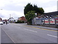
Halesowen Scrapyard
The view in Nimmings Road Rowley Regis.
Image: © Gordon Griffiths
Taken: 28 May 2011
0.04 miles
4
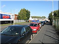
Overflow car park
Cars line the B4169, unable to get a space in Rowley Regis' station car park.
Image: © Peter Whatley
Taken: 9 Oct 2008
0.08 miles
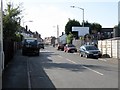
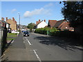
5
Nimmings Road
The view in Rowley Regis on the border of Halesowen.
Image: © Gordon Griffiths
Taken: 28 May 2011
0.09 miles
6

Sandwell Border
The view from Nimmings Road in Halesowen Dudley towards Rowley Regis.
Image: © Gordon Griffiths
Taken: 28 May 2011
0.10 miles
8
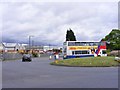
Island Bus
The view across the roundabout down Cakemore Road near Rowley Regis Railway Station.
Image: © Gordon Griffiths
Taken: 28 May 2011
0.12 miles
9
Platform View
The view from Station Road bridge of the track at Rowley Regis Railway Station.
Image: © Gordon Griffiths
Taken: 28 May 2011
0.15 miles
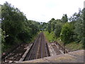
10
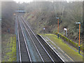
Rowley Regis Station
This is the view towards Stourbridge from the Station Road bridge showing the ends of the platforms at Rowley Regis. The line was opened in 1867 by the independent Stourbridge Railway which was quickly taken over by the Great Western Railway; it continues to be an important part of the West Midlands rail network. Rowley Regis station is actually in Blackheath and was known as Rowley Regis and Blackheath until 1968; perhaps somebody decided that if the name was to be shortened, Rowley Regis sounded grander than Blackheath.
Image: © Stephen McKay
Taken: 4 Jan 2020
0.15 miles