IMAGES TAKEN NEAR TO
Dark Lane, HALESOWEN, B62 0PJ
Introduction
This page details the photographs taken nearby to Dark Lane, B62 0PJ by members of the Geograph project.
The Geograph project started in 2005 with the aim of publishing, organising and preserving representative images for every square kilometre of Great Britain, Ireland and the Isle of Man.

There are currently over 7.5m images from over14,400 individuals and you can help contribute to the project by visiting https://www.geograph.org.uk
Image Map (Loading...)


Getting Data...Please wait
Leaflet Map data © OpenStreetMap
Images are licensed for reuse under creativecommons.org/licenses/by-sa/2.0
Notes
- Clicking on the map will re-center to the selected point.
- The higher the marker number, the further away the image location is from the centre of the postcode.
Image Listing (16 Images Found)
Images are licensed for reuse under creativecommons.org/licenses/by-sa/2.0
Image
Details
Distance
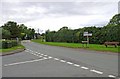
2
St Kenelm's Road Romsley
Junction with Dark Lane
Image: © Geoff Gartside
Taken: 7 Apr 2007
0.05 miles
4
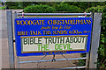
Woodgate Christadelphians notice board, St. Kenelm's Road
The Christadelphians are quite a small Christian sect, with perhaps 18,000 members in the UK, and maybe up to 60,000 worldwide. They don't have any premises in Romsley themselves, but the Woodgate Christadelphians do use the local Scout Centre for many of their activities. This notice board was on a gate near the local playing field/recreation area. Apparently the Christadelphians use the word devil as a reference to sin and human opposition to God. Their beliefs differ quite widely in some areas from the larger established churches.
Image: © P L Chadwick
Taken: 22 Aug 2010
0.07 miles
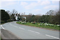
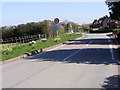
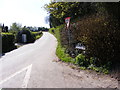
5
Junction of St. Kenelm's Road with Dark Lane
Dark Lane is coming in on the left. Most of the built-up area of the village of Romsley is contained within a triangle, formed by these two roads and Bromsgrover Road (the B4551).
Image: © P L Chadwick
Taken: 22 Aug 2010
0.07 miles
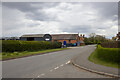
6
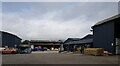
Romsley Country Store, St Kenelm's Road, Romsley
Image: © Jeff Gogarty
Taken: 7 Oct 2021
0.08 miles
7
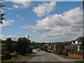
Entering Romsley
The view in St Kenelm's Road near Romsley.
Image: © Gordon Griffiths
Taken: 8 Apr 2011
0.09 miles
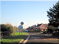
9
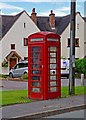
Red telephone kiosk, St. Kenelm's Road
A red BT phone kiosk has survived here, even though it is difficult to imagine that many of the inhabitants of this prosperous village do not own mobile phones! Located near the junction of St. Kenelm's Road with Hillcrest Road.
Image: © P L Chadwick
Taken: 22 Aug 2010
0.12 miles
10
Fieldhouse Lane View
The view from St Kenelm's Road up the Lane near Romsley.
Image: © Gordon Griffiths
Taken: 8 Apr 2011
0.13 miles